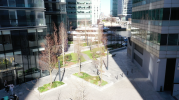
I was flying my Mavic 2 Pro in an urban area with very tall glass buildings for a client. I had no problems when flying from the roof but when I went to fly over some gardens lower down, the drone could not pick up enough satellites and told me it was in Opti mode before launch. I took off to fly forward at about 6m height and noticed that the drone was not holding its position visually but was moving to the left. I decided to bring it back to land it but it suddenly started flying off to sideways the right towards a building. I tried to fly it to the left but it ignored my stick commands, impacted the building and fell causing extensive damage to the drone. Some questions:
1. Why did it drift left in the first place?
2. Why did it fly off to the right afterwards?
3. Why did it ignore my stick commands?
4. Why did the side obstacle sensors not prevent the crash into the building?
My suspicion is that the drone was initially in Opti Mode but then got some satellites which confused it. Perhaps the satellite signals were reflecting off the glass. Either way it is a nuisance that it is not possible to turn the GPS off entirely to fly in atti mode so that there is no risk of this happening.