DJI Mavic, Air and Mini Drones
Friendly, Helpful & Knowledgeable Community
Join Us Now

Mission Planner Surveys to Litchi

Jagerbomb52

Well-Known Member
Joined
Apr 6, 2018
Messages
1,483
Reactions
2,321
Location
Canada

Convert Mission Planner (ArduCopter) Waypoint Surveys to Litchi CSV Format to execute on DJI Drones​

Over on the Litchi Forum there is a member (@Yaroslav) who is working on integrating Mission Planner Surveys to Litchi.
So far he has a working program still in the Beta stage. You can download his program from Github here:

or you can read about it here on the Litchi Forums:

I'm afraid Mission Planner is a little over my head to comment on. There seems to be a large learning cure at least for this old guy.

Make sure you read the Readme on github.
 
Wow I just took some time to actually reread the instructions and it was pretty basic to make a mapping mission. Still need to get the camera specs for the Air 2S and input them into Mission Planner but other then that its pretty simple. :)
 
  • Like
Reactions: Tufargon
Here are the settings for Air 2S and Air2 in 3:4 aspect ratio (set before flight in DJI Fly camera settings)
Here is how to install it:

  1. Download the file from Google Drive
  2. Place it in the folder: Documents/Mission Planner/
  3. Open Mission Planner
  4. Follow Tutorial on Github
  5. The camera preset should be there in the list all together with the other presets, select it
  6. Don’t forget to set overlapping and sidelapping values.
 
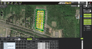
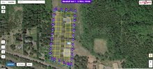
Practicing different missions and getting used to Mission Planner I came up with this mapping mission for my Air 2S at my local baseball field. Being the Air 2S and the known bug in the SDK for the gimbal I will have to manually adjust the gimbal to -90° but not that big of a deal. Once set it will stay there anyways. Its set up with a 70% over lap on the photos. This is a cross grid mission which takes a little longer to complete. Litchi says 10 minutes.

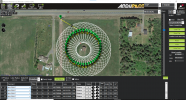
Here is what it looks like in Mission Planner:
Screenshot 2022-02-11 135140.png

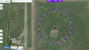
And here it is in Litchi Hub:
screenshot-flylitchi.com-2022.02.11-13_45_41 copy.jpg

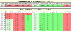
And if the weather ever gets better I will go out and test it out. :)
screenshot-www.uavforecast.com-2022.02.11-14_03_24.png
 
Flew the mission this afternoon. Not one problem other then it being very cold out. Was lucky to be able to sit half in and half out of my truck to watch the mission above. The Air 2S was flawless and the crows flying over head could not figure out the flight pattern so they left us alone. LOL
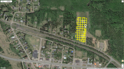
Here is a screen shot of the grid from Airdata. I am uploading the photos to a free account on Maps Made Easy. This will take some time, probably 24 hours to get any results. Also going to run them through a program called 3DF Zephyr to see the results. This will take some time also as my computer is not that fast.
All in all it works very well and @Yaros did a good job making his program.

Screenshot (86).png
 
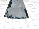
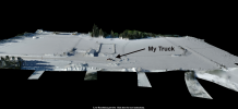
Here is a screen shot of the render from 3DF Zephyr. First time using this program I was surprise at how fast it completed the file. Using Agisoft it usually takes all night to finish.
As you can see it winter here. Lots of snow but the detail is there in the shadows of the trees and the fence line of the baseball fields. Litchi said 10 minutes and it took just over 12 minutes. The extra time could be setup time. I found I had to toggle from camera view to video and back again to get a downlink. Other then that it work very well.

screenshot2.png
 
Not sure if I know which file you mean. Not very experienced in any of this stuff LOL
The OBJ file I just exported and plan on uploading to my google drive soon is 102 MB. It can be viewed with the free 3D viewer from windows.
 
OK here is a link to download the OBJ file. Like I said windows has a 3D viewer for free. If you don't have it just google it for windows and get it. Its free and not the best viewer but does work.
 
Not sure if I know which file you mean. Not very experienced in any of this stuff LOL
The OBJ file I just exported and plan on uploading to my google drive soon is 102 MB. It can be viewed with the free 3D viewer from windows.
Well, you're substantially more experienced than I am with this. Thanks very much for passing along the software suggestions and the example. This looks like another black hole of attention that's going to suck up quite few hours, and yield some good fun.
 
There is a old barn down the highway from me. Always wanted to do a photogrammetry 3d scanning of it. Made a mission and ran it through virtual Litchi and seems to be lined up pretty good. Hopefully will get some warmer weather to try this out.

Screenshot 2022-02-14 104234.png

screenshot-flylitchi.com-2022.02.14-10_37_14.png
 
  • Like
Reactions: Yaros
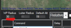
Just a tip: To remove the dotted circles in Mission Planner set the WP Radius to 1.
The setting doesn't do anything in Litchi, it is not even translated in the script, this setting is only relevant to the people using ArduCopter firmware with Mission Planner, not to Litchi users.

1644865989846.png
 
Just a tip: To remove the dotted circles in Mission Planner set the WP Radius to 1.
The setting doesn't do anything in Litchi, it is not even translated in the script, this setting is only relevant to the people using ArduCopter firmware with Mission Planner, not to Litchi users.

View attachment 143911
LOL
I thought it looked kind of cool :p
 
  • Like
Reactions: Yaros
Someone wanted a video tutorial. I'm not very good at making them but here you go.

For someone "not very good", I think your video was an excellent introduction and "how-to" on this subject (and I'm not even familiar with Windows).

Was there some other video you used to learn how to make the 3D Model in your post #12 above? That too is impressive!
 

DJI Drone Deals

New Threads

Forum statistics

Threads
130,592
Messages
1,554,154
Members
159,593
Latest member
mini2+