DJI Mavic, Air and Mini Drones
Friendly, Helpful & Knowledgeable Community
Join Us Now

Sleeping with the fish

justinrr3

Member
Joined
Aug 6, 2023
Messages
7
Reactions
3
Age
33
Location
canada

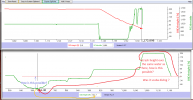
Yesterday I was flying my mini 3 pro and it decided to no input descend. I realized it was going AWOL and hard up pressed the left control stick to counteract the steady drop but no luck.

Last image I saw was murky brown water on my RC controller. I went to the storm pond and it is disgusting (algae filled), with city bylaw notices prohibiting swimming. From what i can tell the water looks very deep...

Any flight log experts see anything weird with the final moments of life? (link is the youtube video)
 
Drone was in Normal mode at the time, I could see the gap between the drone and the water from my lookout point when it started to fly down by itself.

This happened in a open valley, approximately 287 meters away from me. I maintained visual line of site until it hit the water. Battery at the time was more then 20% and RC controller connection was good. No warnings or issues prior to the incident. Weather was clear with little to no wind.
 
Umm at 11:30 to 11:48 the drone reports its height as -100 or more ft and the VPS wasn't registering anything.
At near the end of the flight, 19:33.4, over the same lake, the drone reports its height as 6.6ft and VPS height of 3.6ft and seemingly very near the water's surface.
From your perspective are either of those heights incorrect?
They don't seem compatible with one another over the same body of water and the difference seems, to me, to be too large for barometer drift.

19:27.4 is the point when I stopped controller input (released both sticks). I could see the drone looking from a downward angle and I'd say there was at least 10 meters between it and the pond. This was the point I saw without input it was going down.

19:28.4 I counteract this motion by pressing up on the left stick, no controller connection issues but I can see on the screen as well as visually that it is not responding and still going down,

19:33.6 after decending for a total of 6 seconds it hits the water and disconnects, regardless of controller input. Longest 5 seconds of my life haha
 
  • Like
Reactions: lensimages
IF YOU PRESS BOTH CONTROLLERS INWARD IT WILL MAKE THE DRONE LAND DID YOU DO THAT
If you replay the flight on the Phantomhelp page of post 3 your will see the joystick commands.

If you are refering to the CSC position and wondering if you mean it will kill the drones motors? ....Then, unless the emergency motor stop option is set to "Anytime", the CSC will not stop the drone's motors whilst the drone is in normal flight.
The drone will of course descend but in a controlled helix.
 
  • Like
Reactions: GFields
Umm at 11:30 to 11:48 the drone reports its height as -100 or more ft and the VPS wasn't registering anything.
At near the end of the flight, 19:33.4, over the same lake, the drone reports its height as 6.6ft and VPS height of 3.6ft and seemingly very near the water's surface.
From your perspective are either of those heights incorrect?
They don't seem compatible with one another over the same body of water and the difference seems, to me, to be too large for barometer drift.
IF YOU PRESS BOTH CONTROLLERS INWARD IT WILL MAKE THE DRONE LAND DID YOU DO THAT
Checked back on controller inputs and there was no point where I had both sticks inward to initiate landing
 
Just to clarify, the CSC control position has both control sticks fully in and fully back, or fully out and back.

Moving the sticks only inward results in the drone yawing to the right while moving to its left, resulting in a flight path that I suppose would be level and circular or helical and enlarging, depending on the maximum yaw rate set in the controller.

(Yes, that was a good excuse to put the Mini 3 Pro up, but it's just too windy and gusty for much tinkering with right now.)
 
Checked back on controller inputs and there was no point where I had both sticks inward to initiate landing
I know, my reply to Geemo69 was intended to point him to the joystick postions in the PH replay, and the joystick postions answered Geemo69's "did you do that? " question.
19:27.4 is the point when I stopped controller input (released both sticks). I could see the drone looking from a downward angle and I'd say ther.................
The point of post #5 might be made clearer by the attached. At 691 seconds the drone was apparently more than 107ft lower than the height at the end of the log and at 691 seconds the VPS was not registering proximity to the water surface, which suggests to me that it was maybe more that 30ft above the water's surface. Yes barometers can drift but 100ft + seems a bit excessive to me. I.e. I am wondering if the barometer was playing up.
 

Attachments

  • height discrepency over same lake surface.png
    height discrepency over same lake surface.png
    53.1 KB · Views: 13
Last edited:
I know, my reply to Geemo69 was intended to point him to the joystick postions in the PH replay, and the joystick postions answered Geemo69's "did you do that? " question.

The point of post #5 might be made clearer by the attached. At 691 seconds the drone was apparently more than 107ft lower than the height at the end of the log and at 691 seconds the VPS was not registering proximity to the water surface, which suggests to me that it was maybe more that 30ft above the water's surface. Yes barometers can drift but 100ft + seems a bit excessive to me. I.e. I am wondering if the barometer was playing up.

Initial fly over the pond at 11:35 flight time I can see IMU heigh as -101.7 feet (maybe because take off home point was a higher elevation?) and VPS 15.1 feet. I can confirm VPS height was pretty accurate at this point. I could visually see the gap between drone and water but it was lower compared to the starting point at 19:27 flight time

19:27 IMU was 45.6 feet with N/A for VPS. Again visually I can confirm at this point it was at least double the height of the previous pond fly over and IMU was accurate.
 
Last edited:
My next question about this incident: Did having obstacle avoidance set to bypass cause this? Was the drone in a situation where it was detecting a obstacle above (which was not actually there) causing it to fly down? This is why my inputs to fly up were "bypassed"?

In that 6 second window would a quick sport mode switch to stop OA:bypass in progress would have allowed me to fly up. Or better yet, just flying it in OA:brake would have avoided this incident all together?
 
you must have very good eyes to see that small drone at 1000 ft distance and be able to judge how high it was flying. Sounds to me like it was landing due to loss of signal.
 
Initial fly over the pond at 11:35 flight time I can see IMU heigh as -101.7 feet (maybe because take off home point was a higher elevation?) and VPS 15.1 feet. I can confirm VPS height was pretty accurate at this point. I could visually see the gap between drone and water but it was lower compared to the starting point at 19:27 flight time

19:27 IMU was 45.6 feet with N/A for VPS. Again visually I can confirm at this point it was at least double the height of the previous pond fly over and IMU was accurate.
The barometer/IMU height reported by the drone and seen in the live display of the app and the in the log is relative to the take off point and ALWAYS the take off point. Negative height are therefore possible if the drone flies down slope from the home point That is perfectly fine and not a problem.
The trouble I have with your log is that at 11:40 the drone was, according to the height measured by the VPS sensors 15.7ft above the lake's surface and, as measured by the barometer 101.7ft below the take off point, there is not a problem with this. The lake is below the take off point so those values are as should be.

However,I do have a problem with the heights reported around the time of the crash, the drone was reporting that it was ABOVE the level of the take off point when it crashed. The lake's surface can not have risen 100+ ft in the intervening 6 minutes.
I would question whether or not the barometer etc. was reporting correctly.

One for @slup , @sar104 or @Meta4 perhaps.
 
Lycus Tech Mavic Air 3 Case

DJI Drone Deals

New Threads

Forum statistics

Threads
131,137
Messages
1,560,252
Members
160,106
Latest member
devilsown