

You are using an out of date browser. It may not display this or other websites correctly.
You should upgrade or use an alternative browser.
You should upgrade or use an alternative browser.
Would someone please explain how to work around the DJI NFZ confusion?
- Thread starter SNTDENIS
- Start date
the Dade address looks like it could be a similar problem as the sandy one(its on the edge of B and mode C). although TedS post shows they have some goofy rules for wildlife areas.
The floor of that Class B is 6000 ft MSL. You need to learn how to read sectionals before posting on this subject.
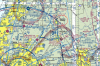
The "plus" sign inside the green circle is where 18435 Townsend House Rd, Dade City, FL plots, right on the edge of Brooksville Class E and under Tampa Class B (and inside the Mode C ring, which as discussed above is unimportant to us). Airmap shows the orange triangle alert symbol and says that the location is inside the Class D airspace and requires FAA authorization. B4UFLY says "Use Caution and Check Restrictions. Proceed with caution. Addditional restrictions may apply in your flight location." DJIGo4 won't allow me to project my position to that address.


Last edited:
brett8883
Well-Known Member
magenta line. mode c extends 30 nautical miles from the airport
SkyVector: Flight Planning / Aeronautical Charts
im dizzy with with all the rules.
That's incorrect. UAVs are specifically exempt from Mode C requirements and do not need any authorization to fly within a Mode C veil.
This is a relief. Pirate flag going back to storage

The "plus" sign inside the green circle is where 18435 Townsend House Rd, Dade City, FL plots, right on the edge of Brooksville Class D and under Tampa Class B (and inside the Mode C ring, which as discussed above is unimportant to us). Airmap shows the orange triangle alert symbol and says that the location is inside the Class D airspace and requires FAA authorization. B4UFLY says "Use Caution and Check Restrictions. Proceed with caution. Addditional restrictions may apply in your flight location." DJIGo4 won't allow me to project my position to that address.View attachment 65186View attachment 65187View attachment 65188
That location appears to be on the edge of the 700 ft Class E - it's well outside the Class D.
Harro
Well-Known Member
The floor of that Class B is 6000 ft MSL. You need to learn how to read sectionals before posting on this subject.
yup. crawling back into my hole. forgot to check the floor. i am a newb. part time newb at that.
The "plus" sign inside the green circle is where 18435 Townsend House Rd, Dade City, FL plots, right on the edge of Brooksville Class E and under Tampa Class B (and inside the Mode C ring, which as discussed above is unimportant to us). Airmap shows the orange triangle alert symbol and says that the location is inside the Class D airspace and requires FAA authorization. B4UFLY says "Use Caution and Check Restrictions. Proceed with caution. Addditional restrictions may apply in your flight location." DJIGo4 won't allow me to project my position to that address.
Kadras. how do you get skyvector to mark the address like that?
silverdragon
Well-Known Member
Hate to say this but The DJI Consumer drone product is not for everyone. DJI protects themself in every possible way in not making the 6 O'clock news " DJI Consumer drone has taking out 747 Passenger Jet with 180 passengers' so we people in the hobby or business of flying drones has to make that decision "Do I want to bare the inconveniences of owning and flying the DJI Drone Product? If yes, buy them....if not, don't buy them.
I meant E (magenta tint), but Airmap claims it's in Class D. Just another example of how these apps (Airmap, B4UFLY, others?) are confusing and misleading.That location appears to be on the edge of the 700 ft Class E - it's well outside the Class D.
> I got the coordinates of the address from Google Maps, in decimal degreess. 28.428926, -82.321699Kadras. how do you get skyvector to mark the address like that?
> In SkyVector, select "Flight Path" in the upper left corner. Enter the coordinates from Google Maps into the blank area of the Flight Path and hit enter.
> SkyVector converts the coordinates into the format it likes and places a magenta and white marker at the coordinates. The cross is marker at the center of the map. I just scrolled the map to put the cursor over the marker.
> In SkyVector, right clicking on the map gives a drop down box at the cursor showing nearby features and their coordinates, and a "GPS" set of coordinates which is the position of the cursor. Selecting the "Plan" button next to any of the items in the list box adds that item to the Flight Path and a marker on the map.
> With just two points, a magenta line is created showing distance and bearing between the two points. Continuing to click on the map will draw a flight path and the coordinates of each point are recorded in the Flight Path.
Flycaster
Well-Known Member
Yes - what would happen if cars had limiters?
Volvo is now going to limit the maximum speed of all their cars to 112 MPH (or whatever in kph).
Volvo is limiting its cars to a top speed of 112 mph
yup. crawling back into my hole. forgot to check the floor. i am a newb. part time newb at that.
Sorry - don't let me put you off - just trying to minimize incorrect information. Sometimes these threads just get washed away with speculation.
I meant E (magenta tint), but Airmap claims it's in Class D. Just another example of how these apps (Airmap, B4UFLY, others?) are confusing and misleading.
View attachment 65190
I don't trust any of those apps. I use Foreflight pretty much exclusively these days.
> I got the coordinates of the address from Google Maps, in decimal degreess. 28.428926, -82.321699
> In SkyVector, select "Flight Path" in the upper left corner. Enter the coordinates from Google Maps into the blank area of the Flight Path and hit enter.
> SkyVector converts the coordinates into the format it likes and places a magenta and white marker at the coordinates. The cross is marker at the center of the map. I just scrolled the map to put the cursor over the marker.
> In SkyVector, right clicking on the map gives a drop down box at the cursor showing nearby features and their coordinates, and a "GPS" set of coordinates which is the position of the cursor. Selecting the "Plan" button next to any of the items in the list box adds that item to the Flight Path and a marker on the map.
> With just two points, a magenta line is created showing distance and bearing between the two points. Continuing to click on the map will draw a flight path and the coordinates of each point are recorded in the Flight Path.
Thank you.
Sorry - don't let me put you off - just trying to minimize incorrect information. Sometimes these threads just get washed away with speculation.
all good man. i just get too geeked up about drones and put my foot in my mouth. i reckon making mistakes on a forum is better than making them in the field though.
appreciate your knowledge anyway.
AMann
Well-Known Member
I don't trust any of those apps. I use Foreflight pretty much exclusively these days.
I bought paper sectionals for checking my flight areas, real ones!
")
Download them directly from the FAA, they're a lot cheaper (free).I bought paper sectionals for checking my flight areas, real ones!
AMann
Well-Known Member
Download them directly from the FAA, they're a lot cheaper (free).
Thanks, but I never figured out how to hang my iPad for display on a wall.
No, really- paper works in that it’s not another memory eating file on my iPhone. Plus the paper maps have all the information on the margins. Plus I’m an old fart so I know how to fold paper maps!
")
Last edited:
MKurr
Well-Known Member
Hack thread?Good reason to look to the hack thread. I’ve been fortunate to have not been in your situation, but I’m sure it will happen soon enough.
Hope all works out in whatever direction you go.
Similar threads
- Replies
- 4
- Views
- 5K
- Replies
- 14
- Views
- 4K
- Replies
- 7
- Views
- 5K
- Replies
- 33
- Views
- 11K


DJI Drone Deals
New Threads
-
-
-
 Air 2s Lavaux, UNESCO listed vineyards in Switzerland
- Started by FlyingDutchman90
- Replies: 0
-

-

Forum statistics
