

Works for all drones. I used 137 photos and took about 20 minutes to process in Metashape. Very powerful software, will be posting more ways to use it. This is a quick entry into the 3D photogrammetry game.

You are using an out of date browser. It may not display this or other websites correctly.
You should upgrade or use an alternative browser.
You should upgrade or use an alternative browser.
3D Photogrammetry with Metashape
- Thread starter Jug's Life
- Start date
-
- Tags
- photogrammetry
That’s awesome - I really appreciate how accessible you’ve made photogrammetry in this clip. People should be inspired to try it!
I have one recommendation from my explorations of DSLR and drone-originated imagery for photogrammetry in RealityCapture:
Choosing an overcast day for imaging means very few (if any) shadows, which is great for 3D film/game workflows using Blender or a game engine or whatever, because that means you can later relight the scene as you wish.
On the other hand, I’m sure there are many applications for photogrammetry where baked-in lighting doesn’t matter very much.
Good advice. I am working my way through the various options. Pix4D should be uploaded tomorrow.That’s awesome - I really appreciate how accessible you’ve made photogrammetry in this clip. People should be inspired to try it!
I have one recommendation from my explorations of DSLR and drone-originated imagery for photogrammetry in RealityCapture:
Choosing an overcast day for imaging means very few (if any) shadows, which is great for 3D film/game workflows using Blender or a game engine or whatever, because that means you can later relight the scene as you wish.
On the other hand, I’m sure there are many applications for photogrammetry where baked-in lighting doesn’t matter very much.
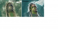
I am doing some comparation between Metashape and DroneDeploy.
For the same number of pictures (245), it looks to me DroneDeploy show a better quality.
Pictures with DJI Mini 3 Pro.
Is it something I miss on Metashape or some special adjustment?
Any suggestion is welcome.
I did upload on Sketchfam the model from Metashape.
Punta De La Guardia, Metashape - 3D model by aerialtasks
Bahia de Maimon, Playabatchata, DR

 sketchfab.com
Punta de la Guardia · 57000, Dominican Republic
For the same number of pictures (245), it looks to me DroneDeploy show a better quality.
Pictures with DJI Mini 3 Pro.
Is it something I miss on Metashape or some special adjustment?
Any suggestion is welcome.
I did upload on Sketchfam the model from Metashape.
Punta De La Guardia, Metashape - 3D model by aerialtasks
Bahia de Maimon, Playabatchata, DR
Punta De La Guardia, Metashape - 3D model by aerialtasks
Bahia de Maimon, Playabatchata, DR https://www.youtube.com/watch?v=0IcPmOko7HY https://www.google.com/maps/place/Punta+de+la+Guardia/@19.8365992,-70.7718503,93m/data=!3m1!1e3!4m6!3m5!1s0x8eb1f2840db30587:0xfa59c61a15bd4a88!8m2!3d19.8363772!4d-70.7716102!16s%2Fg%2F11h8qy2qhz - Punta De La...
sketchfab.com
Punta de la Guardia · 57000, Dominican Republic
Attachments
Last edited:
The best teacher is failure. The second best is experimenting. That being said. Default Drone Deploy can be better than default Metashape. My suggestion is when aligning photos in Meta, expand Advanced and for key point limit try 200,000 and for tile point put 0 (unlimited, it wont affect processing that much). Maybe even 300,000 because this model has lots of gaps of air. Try that, putting settings to high if you havent already. Theres a lot of help to inside Metashape in the help section. Thats what I mostly used to figure it out. And their Agisoft website forum.
AirBoudreaux
Well-Known Member
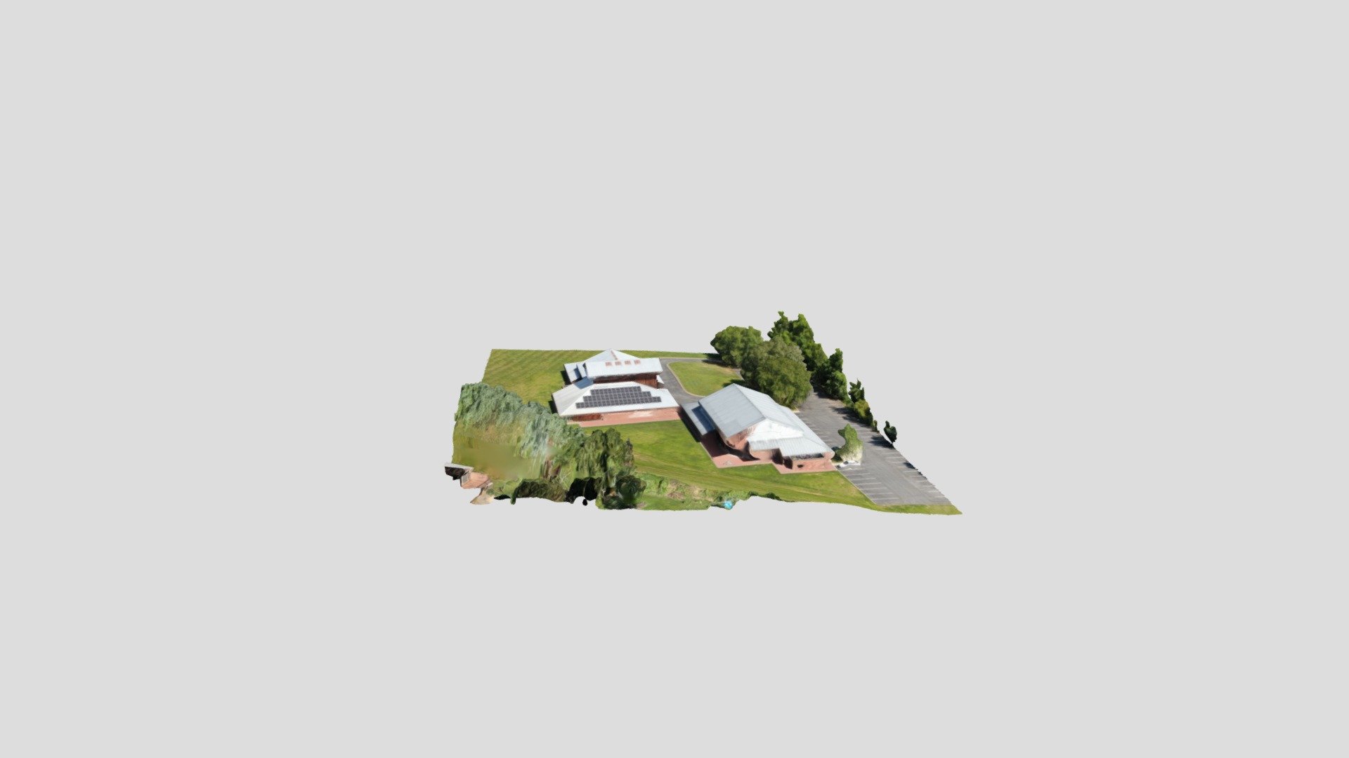
So I've just created my first model with a hyperlapse that I just happened to have saved. Looks pretty solid. My question is now, how do I export a useable 3D model? Do I have to upload this model to another program like ArcGIS? Now that the model is mad, how would I go about getting it to a client to use?
I am using Sketchfab - The best 3D viewer on the web to upload and share my 3D model. Metashape has a tool to export to sketchfab.So I've just created my first model with a hyperlapse that I just happened to have saved. Looks pretty solid. My question is now, how do I export a useable 3D model? Do I have to upload this model to another program like ArcGIS? Now that the model is mad, how would I go about getting it to a client to use?
AirBoudreaux
Well-Known Member
How do I go about doing that? I have an account with sketchfab but cant seem to find how to do it.Metashape has a tool to export to sketchfab.
ETA: I think I may have found how to do it....
It starts uploading but I keep getting an error code:
"Error transferring https:api.sketchfab.com/v3/models - server replied: Bad Request (status code: 400)"
Last edited:
I just file>export model and send it to its own folder, then I winRAR compress the folder and then upload the rar to sketchfab. there is also a method to just compress the model file and then upload the texture file afterward but I have had troubles doing it that way.How do I go about doing that? I have an account with sketchfab but cant seem to find how to do it.
ETA: I think I may have found how to do it....
It starts uploading but I keep getting an error code:
"Error transferring https:api.sketchfab.com/v3/models - server replied: Bad Request (status code: 400)"
AirBoudreaux
Well-Known Member
Ok, so I just zipped the .obj file and uploaded it and it worked. So now my question is downloading in a useable format. I normally share my deliverables via google drive or a 16gb jump drive. I have downloaded all 3 file options but none open to actually view the model. How do I go about downloading these where I can transfer them to a client for use?? Or is that not a possibility? I see the "Share to" links and the "embed link". Is that pretty much the only way to transfer these to clients? Just give them the link to the model and have them share it from there?I just file>export model and send it to its own folder, then I winRAR compress the folder and then upload the rar to sketchfab.
Last edited:
Send them the share link and they can see it online via sketchfab. If you have your own website, you can use embed, to embed and share it directly on your own website.
For deliverables. Thats up to your client. Most of mine have a cloud service they already using for their office and I just upload to that. I dont usually zip it up for clients. No need to. Cloud and high speed internet everywhere. Not a big deal if it takes 5 minutes or 15 to upload.
For deliverables. Thats up to your client. Most of mine have a cloud service they already using for their office and I just upload to that. I dont usually zip it up for clients. No need to. Cloud and high speed internet everywhere. Not a big deal if it takes 5 minutes or 15 to upload.
AirBoudreaux
Well-Known Member
Got it! Thanks for your help! I was able to upload it to my website and I'm sure my clients will be able to do the same. That whole process was a LOT easier than I expected it to be in all honesty.Send them the share link and they can see it online via sketchfab. If you have your own website, you can use embed, to embed and share it directly on your own website.
For deliverables. Thats up to your client. Most of mine have a cloud service they already using for their office and I just upload to that. I dont usually zip it up for clients. No need to. Cloud and high speed internet everywhere. Not a big deal if it takes 5 minutes or 15 to upload.
Im sure this is just the tip of the iceberg with Metashape though. Do you have any other videos that might go a little further in depth as to what else the software is capable of? Ill be toying around with it for a while. I'm just trying to wrap my head around it while I still have the free trial going for me!
Thanks again! I really appreciate your help!
Works for all drones. I used 137 photos and took about 20 minutes to process in Metashape. Very powerful software, will be posting more ways to use it. This is a quick entry into the 3D photogrammetry game.
Thanks for the video tutorial. I don't know what I've been doing wrong but my projects have taken multitudes longer to build than it did following your video step-by-step. I think I've been doing some unnecessary building etc.
I just did one (109 JPG's) and it processed in 12 minutes. I'll take that
")
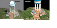
@JAMBCA any suggestions how to improve this one? It's better than my previous models but there has to be something I can do to get more details in the ends of the structure etc.
 skfb.ly
I know that the trees on one end are partially blocking the Data and I suspect I should fly slightly lower to get more detail but there are some massively tall trees around this property (I edited them out of the model to make processing quicker) that I couldn't go less than 140ft AGL.
Heart Theater AUG 2023 - 3D model by BigAl07
Test run of CAPTURE options - Heart Theater AUG 2023 - 3D model by BigAl07
skfb.ly
I know that the trees on one end are partially blocking the Data and I suspect I should fly slightly lower to get more detail but there are some massively tall trees around this property (I edited them out of the model to make processing quicker) that I couldn't go less than 140ft AGL.
The geometry looks good, the textures are decent. A little muddy in some parts.@JAMBCA any suggestions how to improve this one? It's better than my previous models but there has to be something I can do to get more details in the ends of the structure etc.
Heart Theater AUG 2023 - 3D model by BigAl07
Test run of CAPTURE options - Heart Theater AUG 2023 - 3D model by BigAl07
I know that the trees on one end are partially blocking the Data and I suspect I should fly slightly lower to get more detail but there are some massively tall trees around this property (I edited them out of the model to make processing quicker) that I couldn't go less than 140ft AGL.
How many pics was this and what angles. I guess the trees that are missing are the issue of getting better angles/closer.
How many orbits.
My average is about 450 photos, 3 orbits, elevation change of 15 feet per per orbit.
You can also take some ground pics, even from a phone or just holding the drone and taking pics, this can help fill in more details.
My eye went to the areas of the main(?) building that are shadowed under the eves. It looks like there wasn’t enough data in these areas for a good model… though I have to say I am not doing much better!!@JAMBCA any suggestions how to improve this one? It's better than my previous models but there has to be something I can do to get more details in the ends of the structure etc.
Heart Theater AUG 2023 - 3D model by BigAl07
Test run of CAPTURE options - Heart Theater AUG 2023 - 3D model by BigAl07
I know that the trees on one end are partially blocking the Data and I suspect I should fly slightly lower to get more detail but there are some massively tall trees around this property (I edited them out of the model to make processing quicker) that I couldn't go less than 140ft AGL.
Just keep doing what you are doing. Success is always built from failures. Every model we learn something new.My eye went to the areas of the main(?) building that are shadowed under the eves. It looks like there wasn’t enough data in these areas for a good model… though I have to say I am not doing much better!!
The geometry looks good, the textures are decent. A little muddy in some parts.
How many pics was this and what angles. I guess the trees that are missing are the issue of getting better angles/closer.
How many orbits.
My average is about 450 photos, 3 orbits, elevation change of 15 feet per per orbit.
You can also take some ground pics, even from a phone or just holding the drone and taking pics, this can help fill in more details.
I did a regular grid, then the perpendicular grid, then a single orbit. All done at -65deg using Drone Deploy. I need to go back and add more orbits at lower and lower heights to help get more DATA in those lacking areas.
I was thinking of doing some individual pics of key areas (under eaves, between trees and structure etc) but wasn't sure if the software can integrate those correctly into the model with them not being "sequential" per say.
I appreciate your input. I'm hoping to get MUCH better at this so I can improve my deliverables. It's gotten a LOT better but I've got a LOT of room for more improvement as well.My eye went to the areas of the main(?) building that are shadowed under the eves. It looks like there wasn’t enough data in these areas for a good model… though I have to say I am not doing much better!!
@JAMBCA if I take additional images (manual flight) does the software know how/where to place them or so I have to do something "special" to the software knows how/where to add the "different" images? I'm talking about images taken from the drone but taken during manual flight and from various camera angles etc.
Similar threads


DJI Drone Deals
1. Mini 2
2. Mini 3 Pro
3. Mini 4 Pro
4. Air 2s
5. Air 3
6. Avata 2
7. Mavic 3 Pro
8. Mavic 3 Classic
2. Mini 3 Pro
3. Mini 4 Pro
4. Air 2s
5. Air 3
6. Avata 2
7. Mavic 3 Pro
8. Mavic 3 Classic
Forum statistics
