D
You are using an out of date browser. It may not display this or other websites correctly.
You should upgrade or use an alternative browser.
You should upgrade or use an alternative browser.
mobilehomer
Well-Known Member
Department Of Defense. I would not fly CLOSE to that one!!
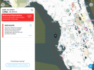
According to AIRMAP, it's the US Territorial Waters Boundaries-41.
I imagine the area may be patrolled.
I imagine the area may be patrolled.
Air Aware - The Leading Airspace & Situational Awareness Tool for Drone Operators
Can I fly my drone here? Use Air Aware on the web or mobile devices to check the airspace for federal & local UAS rules & regulations before taking flight.
(The link above opens B4YOUFLY on the web at the approximate location.)
The "more" button shows a little more information. It's related to U.S. territorial waters, out 12 nm from the shore and wraps around the entire shoreline of the country. It's a restriction against approaching military vessels without authorization. Drones are required to stay 3000' feet horizontally and 1000' above military vessels.
My (amateur, unofficial) understanding is that as long as you don't approach a military vessel within 3000', there's no limitation on operating in the area you selected. With any of the drones I fly, a boat is going to be necessary that far offshore.
It's interesting that B4YOUFLY only tags the restriction if you choose a location close to or within the boundary line itself. Anyone have an explanation for that? The map below behaves the same way.
That note and another on minimum distances from military vessels shows up on this site - National Security UAS Flight Restrictions.

National Security UAS Flight Restrictions
National Security UAS Flight Restrictions
udds-faa.opendata.arcgis.com
[Speaking of odd regulatory situations not likely to happen, do the procedures for crossing an ADIZ (Air Defense Identification Zone) apply to drones?]
Faster
Well-Known Member
If you zoom in to the B4UFLY app that line representing the US Territorial Waters Boundaries looks a few miles wide. Would like to know the real extension?
D
Deleted member 160650
Guest
Sure I guess, if you were to fly in it could you get your ticket pulled?If you zoom in to the B4UFLY app that line representing the US Territorial Waters Boundaries is a few miles wide. Would like to know the real extension?
LoudThunder
Part 107 Licensed
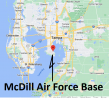
McDill Air Force Base is only about 50-miles southeast of this location and the Air Force might have that area either permanently or temporarily reserved for air operations.
MacDill Air Force Base > Home

MacDill Air Force Base > Home

Last edited:
No. It's a flight restriction, not a flight prohibition, and the restriction relates only to flying near military vessels.Sure I guess, if you were to fly in it could you get your ticket pulled?
McDill Air Force Base is only about 50-miles southwest of this location and the Air Force might have that area either permanently or temporarily reserved for air operations.
MacDill Air Force Base > Home
View attachment 144957
If there were limitations related to McDill, they would be indicated on the charts or in a TFR. Unrelated.
Notice that the line extends all around the coast of the US, not just near that AFB.
D
Deleted member 160650
Guest
Is there military vessels circling the us? Kinda cool thoughNo. It's a flight restriction, not a flight prohibition, and the restriction relates only to flying near military vessels.
I am a marine vet. and I can you that our military base's are on some type of alert status. because everything that is going on over seas. The military bases get put on some type of alert, most of the time, and security, areas around the bases, including air space gets extended around all of the base, depending on the alert status.
in other words...I would not fly there, especially if there are TFRs, you will and for sure, if the drone is seem by security - military, lose your drone, for sure, even if no one comes and said anything to you.
expensive price to pay for having some little excitement with your drone.
Just think about what is going on. I do not want to talk too much about it in this forum, because this is not the place for it. especially the parties that are involved.
Last edited:
GregS
Well-Known Member
The Gulf Coast is an area where military planes from NAS Pensacola and Eglin Air Force Base fly to practice many things; like target practice, dog fighting, many different maneuvers. On the map it might beView attachment 144956On B4UFLY I found thismrestricted zone off the coast and wondered what it’s for and if it actually matters if I fly there.
labeled; Warning Area. Don't even go close to it!!!
Bill Dunnuck
Well-Known Member
- Joined
- Apr 18, 2018
- Messages
- 223
- Reactions
- 190
- Age
- 81
asditty
Member
That notice is not due to a general alert for military bases, Coast Guard or aircraft routes, or any particular military base. Look at the B4YOUFLY app or at the web version. You'll find the same notice all along the territorial waters boundary around the entire United States shoreline. Read the entire notice. It's just telling you not to get close to military vessels.
 b4ufly.aloft.ai
Air Aware - The Leading Airspace & Situational Awareness Tool for Drone Operators
Can I fly my drone here? Use Air Aware on the web or mobile devices to check the airspace for federal & local UAS rules & regulations before taking flight.
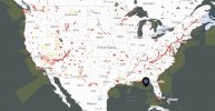
The notice the OP saw has nothing to do with the offshore warning areas in the Gulf. There are similar warning areas on every coast; they're the tan areas in the image below.The Gulf Coast is an area where military planes from NAS Pensacola and Eglin Air Force Base fly to practice many things; like target practice, dog fighting, many different maneuvers. On the map it might be
labeled; Warning Area. Don't even go close to it!!!

Here's how the FAA regs describe them.
"3-4-4. Warning Areas
A warning area is airspace of defined dimensions, extending from three nautical miles outward from the coast of the U.S., that contains activity that may be hazardous to nonparticipating aircraft. The purpose of such warning areas is to warn nonparticipating pilots of the potential danger."
Since they begin three miles offshore, they have little to do with our types of drone operations. And they're warning areas only not prohibited airspace.
The big issue for drones in the Florida Panhandle is the restricted and prohibited airspace around NAS Pensacola, Eglin AFB, Hurlburt Field, and all the outlying fields and MOAs. The FAA's B4YOUFLY app clearly shows where you can and can't fly. You can also find it on the web.
Air Aware - The Leading Airspace & Situational Awareness Tool for Drone Operators
Can I fly my drone here? Use Air Aware on the web or mobile devices to check the airspace for federal & local UAS rules & regulations before taking flight.
D
Deleted member 154956
Guest
National Security UAS Flight Restrictions are important TFRs that cover sensitive security locations, usually belonging to the Dept. of Energy or Dept. of Defense. And as an added bonus, as a retired US Navy weapons Fire Contolman, if your drone penetrated this restricted flight area, I would be authorized to shoot it down! Sorry, that's how that works! And if you're thinking your drone is too small or too fast, not really. The Phalanx Close-In-Weapon-System (CIWS -terminal defense role) is capable of tracking a target with a radar cross section the size of 1/4 the area of a .22 caliber bullet, traveling at greater than the speed of sound. (far greater, it's still classified).
Last edited by a moderator:
LA 2020
Well-Known Member
Department of Defense warning so do not even go close unless you want to loose your drone. This is even higher than the FAAView attachment 144956On B4UFLY I found thismrestricted zone off the coast and wondered what it’s for and if it actually matters if I fly there.
Warning Areas are a different thing. This is a Restriction that applies to coastal waters out to 12 nm. It's simply telling UAS operators not to fly close to military vessels. It's not a prohibition against flying in the coastal waters.Department of Defense warning so do not even go close unless you want to loose your drone. This is even higher than the FAA
Look at the specific reference - FDC 0/0852. I've included a copy below with the key parts highlighted in red text.
From the UAS Facility Map.
ArcGIS Web Application
 www.arcgis.com
UAS Flight Restriction
| Proponent | DOD |
| Branch | USN |
| Base | |
| Facility | US Territorial Waters Boundaries-41 |
| Airspace | Airspace over waters from US shore to line (12NM) |
| Reason | NATIONAL SECURITY. See FDC 0/0852. Unmanned Aircraft (UA) operations are prohibited within 3,000 ft. laterally and 1,000 ft. above military vessels. Operating in the indicated airspace may result in disruption, seizure, or destruction of UA. |
UAS NOTAM FDC 0/0852
FDC 0/0852..FDC SECURITY..SECURITY SPECIAL SECURITY INSTRUCTIONS FOR UNMANNED AIRCRAFT SYSTEM (UAS) OPERATIONS WITHIN AND IN THE VICINITY OF AIRSPACE OVERLYING THE TERRITORIAL AND NAVIGABLE WATERS OF THE UNITED STATES OF AMERICA (USA).
PURSUANT TO 49 USC SECTION 40103(B)(3), THE FAA CLASSIFIES THE AIRSPACE DEFINED IN THIS NOTAM AND IN FURTHER DETAIL BY THE FAA WEBSITE IDENTIFIED BELOW AS 'NATIONAL DEFENSE AIRSPACE'. OPERATORS WHO DO NOT COMPLY WITH THE FOLLOWING PROCEDURES MAY FACE THE FOLLOWING ENFORCEMENT ACTIONS: THE UNITED STATES GOVERNMENT MAY PURSUE CRIMINAL CHARGES, INCLUDING CHARGES UNDER 49 USC SECTION 46307; AND THE FAA MAY TAKE ADMINISTRATIVE ACTION, INCLUDING IMPOSING CIVIL PENALTIES AND REVOKING FAA CERTIFICATES OR AUTHORIZATIONS TO OPERATE UNDER TITLE 49 USC SECTIONS 44709 AND 46301.
IN ADDITION, PURSUANT TO 10 USC SECTION 130I, THE DEPARTMENT OF DEFENSE (DOD) MAY TAKE SECURITY ACTION THAT RESULTS IN THE INTERFERENCE, DISRUPTION, SEIZURE, DAMAGING, OR DESTRUCTION OF UNMANNED AIRCRAFT CONSIDERED TO POSE A SAFETY OR SECURITY THREAT TO PROTECTED DOD ASSETS. PURSUANT TO 14 CFR SECTION 99.7, SPECIAL SECURITY INSTRUCTIONS (SSI), ALL UNMANNED AIRCRAFT ARE PROHIBITED FROM FLYING WITHIN A STAND-OFF DISTANCE OF 3000FT LATERALLY AND 1000FT ABOVE ANY U.S. NAVY (USN) VESSEL OPERATING, TRANSITING, OR AT PORT WITHIN THE TERRITORIAL WATERS AND/OR NAVIGABLE WATERS OF THE USA. THE AIRSPACE IN WHICH UAS OPERATIONS MUST COMPLY WITH THIS SSI IS DEFINED AS THE AIRSPACE, SFC-2000FT MSL, ABOVE THE TERRITORIAL AND NAVIGABLE WATERS OF THE USA, INCLUDING PORTS, ANCHORAGES AND ADJACENT LAND. THE TERRITORIAL WATERS OVER WHICH THIS SSI APPLIES ARE VISUALLY DEPICTED AND GEOSPATIALLY DEFINED ON THE FOLLOWING FAA WEBSITE: HTTPS://UDDS-FAA.OPENDATA.ARCGIS.COM
NAVIGABLE WATERS OF THE USA ARE DEFINED BY 33 CFR PART 329. ADDITIONAL SECURITY-RELATED UAS RESTRICTIONS ARE DEPICTED ON HTTPS://UDDS-FAA.OPENDATA.ARCGIS.COM
UAS OPERATORS NEEDING TO OPERATE IN THE DEFINED AIRSPACE IN CLOSE PROXIMITY TO USN VESSELS OPERATING IN TERRITORIAL AND NAVIGABLE WATERS OF THE USA FOR OVERRIDING REASONS OF PUBLIC INTEREST OR NECESSITY (SUCH AS IN DIRECT SUPPORT OF AN ACTIVE NATIONAL DEFENSE, HOMELAND SECURITY, LAW ENFORCEMENT, FIREFIGHTING, SEARCH AND RESCUE, OR DISASTER RESPONSE MISSION; OR COMMERCIAL ACTIVITY) MUST COORDINATE AND OBTAIN ADVANCE AUTHORIZATION FROM THE APPROPRIATE DOD/USN POINT OF CONTACT IDENTIFIED IN THE FOLLOWING FAA WEBSITE: HTTPS://UDDS-FAA.OPENDATA.ARCGIS.COM. OPERATORS UNABLE TO SUCCESSFULLY COORDINATE WITH THESE DOD OR USN POINTS OF CONTACT MAY CONTACT THE FAA SYSTEM OPERATIONS SUPPORT CENTER (SOSC) AT (202)267-8276 FOR FURTHER ASSISTANCE.
IF YOU HAVE GENERAL QUESTIONS REGARDING UAS OPERATIONS, PLEASE REFER TO WWW.FAA.GOV/UAS/CONTACT; OR CONTACT THE FAA VIA EMAIL AT [email protected] OR PHONE AT (844) FLY-MY-UA.
IF YOU HAVE QUESTIONS REGARDING THESE UAS SSI, PLEASE REFER TO THE FOLLOWING FAA WEBSITE: HTTPS://UDDS-FAA.OPENDATA.ARCGIS.COM; OR CONTACT THE FAA’S SOSC AT (202)267-8276.
Good info here. Adding an authoritative source:

Getting there was a bit weird. It's listed under Documents after clicking on the search box.
It is accompanied by FDC 1/5318 for the navigable waters of the United States of America.

Getting there was a bit weird. It's listed under Documents after clicking on the search box.
It is accompanied by FDC 1/5318 for the navigable waters of the United States of America.
Similar threads
- Replies
- 22
- Views
- 4K
- Replies
- 2
- Views
- 918
- Replies
- 53
- Views
- 2K
- Replies
- 29
- Views
- 1K
DJI Drone Deals
1. Mini 2
2. Mini 3 Pro
3. Mini 4 Pro
4. Air 2s
5. Air 3
6. Avata 2
7. Mavic 3 Pro
8. Mavic 3 Classic
2. Mini 3 Pro
3. Mini 4 Pro
4. Air 2s
5. Air 3
6. Avata 2
7. Mavic 3 Pro
8. Mavic 3 Classic
New Threads
-
-
-
Air 3 Loch Kinardochy - Spring Highland Sunshine
- Started by AlbionDrones
- Replies: 0
-
-
Members online
Total: 771 (members: 9, guests: 762)


