DJI Mavic, Air and Mini Drones
Friendly, Helpful & Knowledgeable Community
Join Us Now

DJI Mavic pilots - Australia

Hi Betchaboy,

was thinking of doing my repl & roc with droneit... who would you suggest....
Thanks

BTW.. am in northeast suburbs of melbourne, would love to get to know some new drone friends.
 
Hey wolfborg,

I don't know that I can recommend someone, so much as not recommend someone. Given that I only used one provider, that is the only one I can really comment on from personal experience.

I did mine online with Droneit, but to be honest I would not recommend them. I found their courseware and student portal design very poor, and the although their course covered the required content (as any course needs to) they did not do it effectively in my opinion.

When I started the online course they had a discussion forum where students could help each other, but that was heavily monitored for negative feedback, and eventually shut down. With no means of learning together with other students that knocked a great deal of usefulness out of the course for me.

The actual lessons of the course were very dull, amounting to narrated slides and lots of dense text. It is a shame because the information itself could be very interesting if presented and taught well, but it wasn't. So instead of being an interesting and challenging course, it became a real drudge to get through.

So, to answer your question, I'm not sure who I'd recommend, but probably not Droneit.
 
i had 1 phone call to Danko Zikic for about 10 minutes of so, and must admit that he was not very happy or talkative about the course or his company. was expecting more...... even sent a email explaining was i was wanting to do and got no reply, except please call us to talk, been there and nothing happened.
 
i
Hi Betchaboy,

was thinking of doing my repl & roc with droneit... who would you suggest....
Thanks

BTW.. am in northeast suburbs of melbourne, would love to get to know some new drone friends.
Ive been delivering this course plus the cert3 aviation/remote pilot for a few years now and really advise looking around until you find someone that seems reasonable. There is a growing amount of cowboys out there willing to deliver this course with copy cut powerpoint slides and little real world experience and take the same money that quality training will set you back
 
what type of operations are you planning to be conducting once all certified?
 
G'day.. Have always been a tech junkie. New to flying, been interested for a while, but the size of the drones have always put me off.
The Mavic really grabbed my attention. Pulled the gun and pre-ordered.

I'm also in Adelaide, Brighton. Slight concern though, my house is 5.5km from the airport (using Google maps distance measurement).
Any issues?
Howdy....

I live in Coffs Harbour, NSW and also live within a large regional Airport.

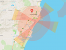
You CAN fly, with In-Flight Unlock and accept the prompts to fly in the zone that is NOT the flight paths.

If you wish to fly within those (Looks like a cross)... forget it.

The light-pink (Usually the "Blue Zone") you can fly but you have to unlock every time you fly... no big deal

Tick the boxes, hit I agree and off you go..

Screen Shot 2021-12-29 at 4.25.09 pm.png
 
No this is incorrect.
yes the drone may start as dji isnt locking you out, but you MUST abide by CASA laws or you are flying illegally.
Use the CASA recommended app - opensky.
When you are “ticking the boxes and stating you agree” you are stating that you understand the requirements for your flight.
The reason the flight approaches are different to the 3nm boundary is that if you were licensed and hold an operators certification, you can get approvals to fly in different areas. The approach areas are different to the 3nm boundary and require different approvals. However, without specific approvals, both are no fly zones. DJI seems not to have as many nfz locked into its own system in australia. But DJI is not the authority on our airspace. CASA is the authority and very clear.

Please dont offer advice when you clearly do not know or understand the rules and regulations in this country. Also i would ask that you do not fly within the 3nm of airport.

As a final piece of advice, Airservices Australia are installing aeroscope in most airports and they WILL track you flight with a fair chance you could be fined.


802F0F79-C5D9-44BA-AA89-84DE62B05EA5.png
 
Last edited:
As much as a pain the layout in the app can be at times...opensky is accurate so you're best to use that (or another CASA approved app) to be safe.
 
I have finally managed to locate the Australian group again. So much of the o/s information does not have much relevance to Australia. I have been flying my Mavic Pro since May 2017, and apart from a few mishaps with broken propellers I have managed to patch it up and keep flying with it. I live in the Adelaide area (SA).
 
Welcome back. There are some differences with overseas, but generally most of the regulators are on the same page
 
I have finally managed to locate the Australian group again. So much of the o/s information does not have much relevance to Australia. I have been flying my Mavic Pro since May 2017, and apart from a few mishaps with broken propellers I have managed to patch it up and keep flying with it. I live in the Adelaide area (SA).

Aussie section always here, but yeah the whole forum is an excellent learning tool for drone pilots.
You and I might have obtained out M1Ps about the same time !
Quite a number of members on the forum in Adelaide.
Keep enjoying the M1P, if the batteries last out, this is one of DJIs most solid products even now.
 
Hi, I looked at the CASA pages for CASA-verified drone safety apps.

Air Map is hard to follow, they flag so many things, it seems there are few open places.

I tried AirPass which seems maybe too permissive. For instance the Sydney area:


All of the Harbour is Do Not Fly. So is all of Vaucluse. But the ocean off the coast of Vaucluse is Fly with Caution?

But Bondi and Bronte are Fly with Caution while Coogee is Do Not Fly.


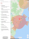
Open Sky seems to have more detailed shaded areas. A lot of it is orange and says "Fly Under Conditions" and lists an airport or heliport nearby.

What does that mean, you ask them permissions to fly at a specific time in those areas and if you get their permission you can fly there?

A lot of these Orange zones have several entities listed or area labels, like hospitals. Do you need to contact each entity?

I clicked the Airservices Australia link to this page:


Looks like a number of contacts so would you seek permissions for each of these orange zones you want to fly in?
 
Open Sky seems to have more detailed shaded areas. A lot of it is orange and says "Fly Under Conditions" and lists an airport or heliport nearby.

What does that mean, you ask them permissions to fly at a specific time in those areas and if you get their permission you can fly there?

A lot of these Orange zones have several entities listed or area labels, like hospitals. Do you need to contact each entity?

Looks like a number of contacts so would you seek permissions for each of these orange zones you want to fly in?

Some of those CASA apps are more for commercial type RePL pilots, flying close to / in restricted areas at times.
Not sure if you are rec pilot only, but sounds like it ?

I have 2 of the CASA approved apps on my phone, Airmap and Opensky.
Opensky is the one I normally check, and Airmap just to verify if unsure about a location.

Opensky has 2 general coloured zones, red for controlled airport zones (no fly or altitude restricted new flight paths), and orange for uncontrolled airport / heli, sometimes special zones around red zones.
You do of course get TFR red zones for fires, accidents etc to keep the airspace clear.

Just move the map so your location is where you wish to fly, look below in the info area text, it will tell you what the deal is for that location and nearby.
Move the map onto nearby zones, check info, avoid if info lists restrictions to whatever altitude etc you may be flying.

So, red zones no fly. Simple.
Orange on fringes of red zones are usually height restricted, eg Adelaide airport fringe orange restricted to 90m.
Orange zones near uncontrolled airports, heli pads etc, you can fly as normal up to 120m (the app will tell you), and as per the notes below 'Use Caution' . . . 'Operating near known heliport (or uncontrolled airport), keep clear of flight paths, safely land if you become aware of aircraft operating in the area' types of messages.

Yes, a lot of Sydney skies are no fly, but areas here and there you can in between most of the larger areas.

So orange zones ok, be very aware near the big hospitals though, lots of heli air traffic there at times, but you usually hear them from well off.
Flying VLOS in these areas is very important so you can react accordingly.

Have fun.
 
  • Like
Reactions: wco81
Yes recreational pilot.

Open Sky has so many orange zones, like in QLD where there appears to be no city of any significant size including inland. I can see hospitals there but every hospital can't have a heliport?

Thanks for the tips.
 
Yes recreational pilot.

Open Sky has so many orange zones, like in QLD where there appears to be no city of any significant size including inland. I can see hospitals there but every hospital can't have a heliport?

Thanks for the tips.

No problems.
Most hospitals have a place a chopper can land, especially in the country regions, and where the hospital has some sort of emergency incident capability.
These might get used rarely, usually regional car accidents.
Of course major hospitals usually have a helipad on a roof top somewhere near the emergency dept.

Don't sweat it too much, for wherever you wish to fly, just do this . . .

Open up the app (Opensky).
Scroll the map over to where you want fly, specifically where you think a good take off point is.
Let it 'think' for the 5 - 10 seconds and when finished, if it comes up green ok to fly, all good.
Still, if near an orange zone you might fly through, just move the map there briefly and see what it says.

If the zone is orange, no matter, read what's there and run with that . . . 'land if you become aware of' etc . . . stick to lower altitude if near red zone fringes and the app say this . . . anything else it might come up with like fires, car crashes, and the likes are usually red zones like fully controlled airports.

I like using the web based version of Opensky at home before going somewhere new, it's easy then to 'look around' and get a pre trip drill on what to expect, not usual to find something different next day, but if going far might pay to have a quick look.
 
  • Like
Reactions: wco81
Lycus Tech Mavic Air 3 Case

DJI Drone Deals

New Threads

Forum statistics

Threads
130,599
Messages
1,554,245
Members
159,603
Latest member
refrigasketscanada