You are using an out of date browser. It may not display this or other websites correctly.
You should upgrade or use an alternative browser.
You should upgrade or use an alternative browser.
DroneViewer - PC/Mac software to view your drone video and flight data simultaneously
- Thread starter wanderer
- Start date
Will you ever add it to DroneViewer?Sorry, no. There are other 3rd-party tools that perform that task.
Just wanted to let folks know we just released DroneViewer v1.1.3 today. If you're not familiar with DroneViewer, here is a short description:
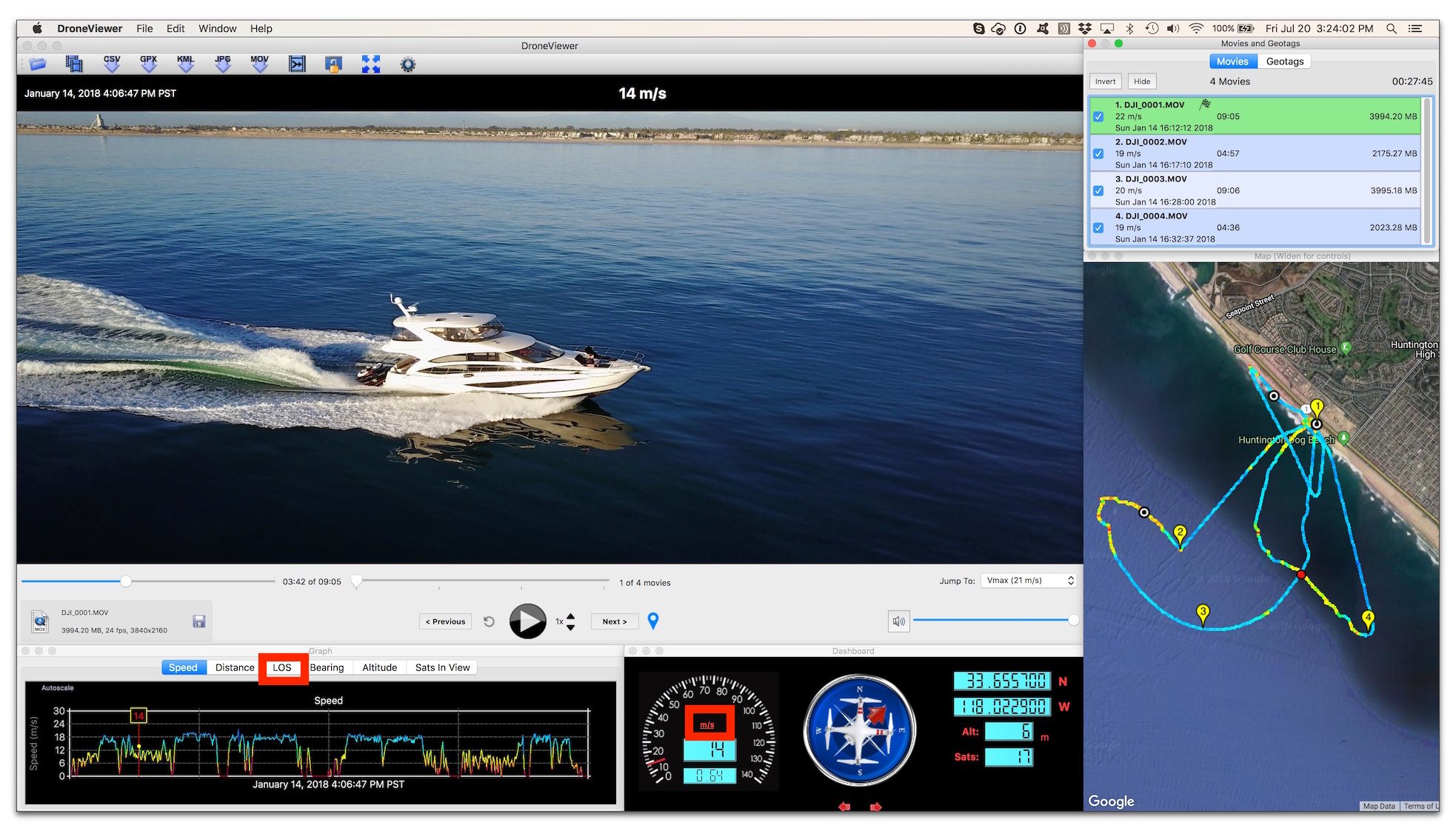
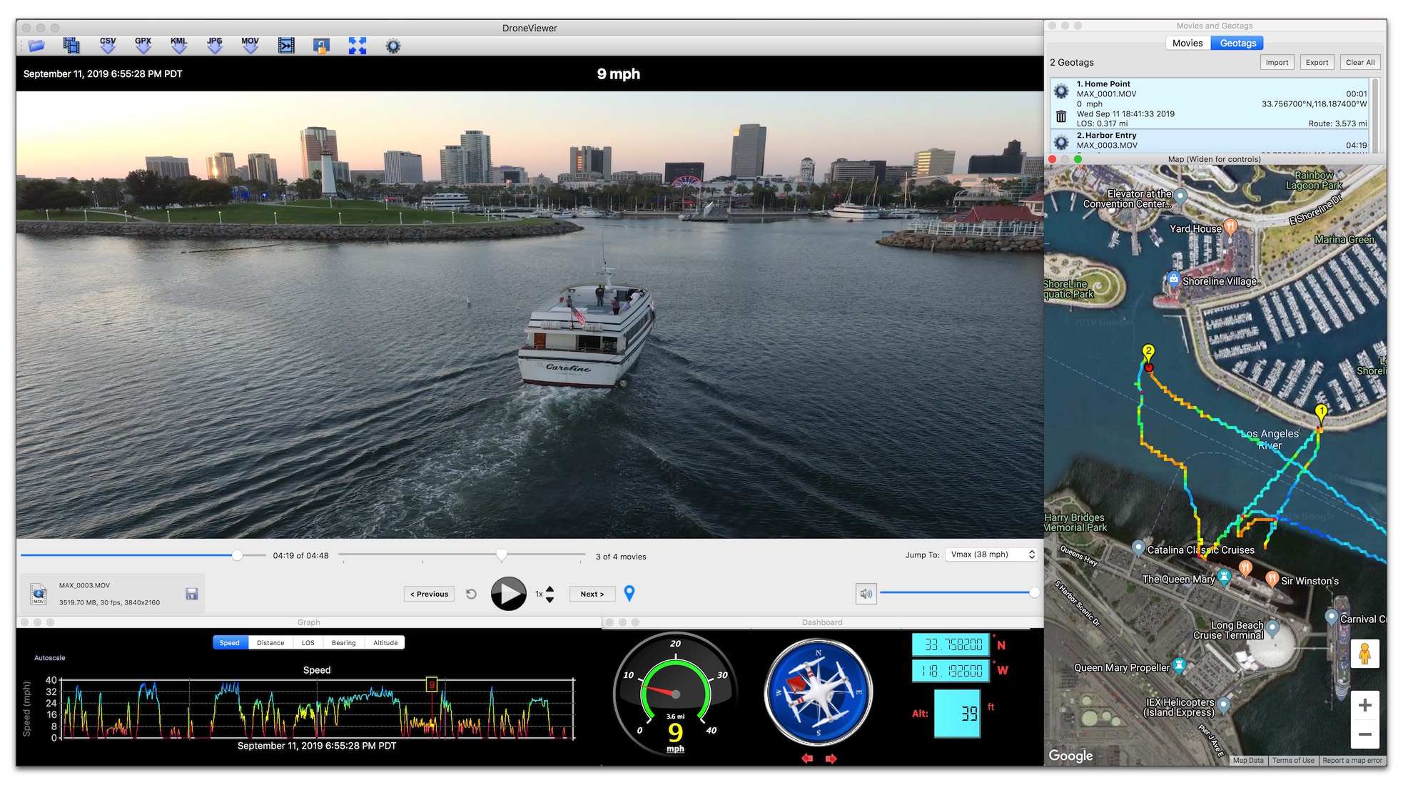
DroneViewer is a Mac and Windows application that lets you play your videos on the main screen while watching your drone's speed, distance, position, and bearing update on graphs, data displays, and maps. You can geotag key points in your route and jump back to them instantly. You can export portions of your videos to separate clips, or export just a single geotagged frame. You can save your route to common file formats such as comma-separated value (CSV), GPS-exchange (GPX), or Google Earth (KML), for further data analysis.
Works with MavicPro, MavicPro2 (tested with fw v01.00.0200), Phantom 3, Phantom 4, and Phantom 4 Pro.
And here are the recent changes.
Version 1.1.3 – March 9, 2019
New Features:
New Features:

DroneViewer is a Mac and Windows application that lets you play your videos on the main screen while watching your drone's speed, distance, position, and bearing update on graphs, data displays, and maps. You can geotag key points in your route and jump back to them instantly. You can export portions of your videos to separate clips, or export just a single geotagged frame. You can save your route to common file formats such as comma-separated value (CSV), GPS-exchange (GPX), or Google Earth (KML), for further data analysis.
Works with MavicPro, MavicPro2 (tested with fw v01.00.0200), Phantom 3, Phantom 4, and Phantom 4 Pro.
And here are the recent changes.
Version 1.1.3 – March 9, 2019
New Features:
- Alt-Return, F11, and Cmd-F (Mac) or Ctrl-F (Win) will all toggle fullscreen mode
- The spacebar-to-pause/resume feature now works even if the main window is
not in the forefront. General Improvements: - The Time Preferences have been simplified. The Auto-Fix Time Offset button, the Always Auto-Fix Time Offset button, and the Time Offset field have all been removed. These have been replaced with a Time Bias field. The Time Bias allows you to fine-tune the synchronization of the video with the drone’s map position. In most cases this can be left at '0' seconds.
- Fixed crash that could occur if all graph y values were identical.
New Features:
- Added compatibility with the SRT files produced by the DJI Mavic 2 Pro using firmware version 01.00.0200. Note that altitude data is missing from the SRT file.
- The Registered version will now display up to 66 minutes of GoPro lat/lon/alt data. Previously, the Registered version would only show 1 minute of GoPro data.
- Improved synchronization between video and data.

RogerMav
Well-Known Member
- Joined
- Nov 13, 2018
- Messages
- 167
- Reactions
- 85
- Age
- 68
Yeah !!!!Just wanted to let folks know we just released DroneViewer v1.1.3 today. If you're not familiar with DroneViewer, here is a short description:
DroneViewer is a Mac and Windows application that lets you play your videos on the main screen while watching your drone's speed, distance, position, and bearing update on graphs, data displays, and maps. You can geotag key points in your route and jump back to them instantly. You can export portions of your videos to separate clips, or export just a single geotagged frame. You can save your route to common file formats such as comma-separated value (CSV), GPS-exchange (GPX), or Google Earth (KML), for further data analysis.
Works with MavicPro, MavicPro2 (tested with fw v01.00.0200), Phantom 3, Phantom 4, and Phantom 4 Pro.
And here are the recent changes.
Version 1.1.3 – March 9, 2019
New Features:
Bug Fixes:
- Alt-Return, F11, and Cmd-F (Mac) or Ctrl-F (Win) will all toggle fullscreen mode
- The spacebar-to-pause/resume feature now works even if the main window is
not in the forefront. General Improvements:- The Time Preferences have been simplified. The Auto-Fix Time Offset button, the Always Auto-Fix Time Offset button, and the Time Offset field have all been removed. These have been replaced with a Time Bias field. The Time Bias allows you to fine-tune the synchronization of the video with the drone’s map position. In most cases this can be left at '0' seconds.
Version 1.1.2 – December 16, 2018
- Fixed crash that could occur if all graph y values were identical.
New Features:
Bug Fixes:
- Added compatibility with the SRT files produced by the DJI Mavic 2 Pro using firmware version 01.00.0200. Note that altitude data is missing from the SRT file.
- The Registered version will now display up to 66 minutes of GoPro lat/lon/alt data. Previously, the Registered version would only show 1 minute of GoPro data.
- Improved synchronization between video and data.

Thanks
Northern_Bob
Well-Known Member
- Joined
- Feb 22, 2019
- Messages
- 74
- Reactions
- 86
I would love to support the Spark, but the Spark doesn't have a "Video Captions" option to export the GPS data.
Northern_Bob
Well-Known Member
- Joined
- Feb 22, 2019
- Messages
- 74
- Reactions
- 86
Yesterday we released DroneViewer v1.1.4 for Mac and Windows. DroneViewer is compatible with the SRT file format of the Mavic Pro, as well as other DJI drones and GPS-enabled GoPro cameras. Changes in v1.1.4 include:
New Features:
DroneViewer has many more features and is available for download on our website: http://mydroneviewer.com
New Features:
- Added support for DJI Matrice 200 SRT file format
- Fixed issue with Google Maps reporting "For development purposes only".
- Fixed bug in which space character would be ignored in Geotag title input dialog
- Fixed minor bug in which the Return key would be ignored when used in theGeotag title window to accept or dismiss the GUI.
DroneViewer has many more features and is available for download on our website: http://mydroneviewer.com
Hi Wanderer, still using your software since you launched it and globally happy with it.
I just have some glitches from the beginning with handling of the map window. Each time I try to reduce its size to make more space for the movies list (default windows layout), the program crash.
Since the beginning I was stuck with the default layout and it would be nice if I can adjust it to my needs.
Also I have a laptop that can have 1 or 2 extra screens attached when I have in the office and currently I have none. It was complicated to move the screens back to the laptop main screen. By chance I remembered the windows shortcuts to activate the window menu and move manually the screen, this after I figured out that all the windows where out of the screen. Would have been nice the software realize it was out of screen and moved it on the current screen.
Thanks in advance for your answer and thanks for the updates all other the time.
I just have some glitches from the beginning with handling of the map window. Each time I try to reduce its size to make more space for the movies list (default windows layout), the program crash.
Code:
Problem signature:
  Problem Event Name:    APPCRASH
  Application Name:    DroneViewer.exe
  Application Version:    0.0.0.0
  Application Timestamp:    5d326ff0
  Fault Module Name:    ig75icd64.dll
  Fault Module Version:    10.18.14.4889
  Fault Module Timestamp:    5a32f45f
  Exception Code:    c0000005
  Exception Offset:    000000000054b0b5
  OS Version:    6.1.7601.2.1.0.256.48
  Locale ID:    1033
  Additional Information 1:    8419
  Additional Information 2:    84198541eea0b2554c9d7251a6bdf23b
  Additional Information 3:    7f50
  Additional Information 4:    7f505c5d7c974067ec4982cfe8fdd178
Since the beginning I was stuck with the default layout and it would be nice if I can adjust it to my needs.
Also I have a laptop that can have 1 or 2 extra screens attached when I have in the office and currently I have none. It was complicated to move the screens back to the laptop main screen. By chance I remembered the windows shortcuts to activate the window menu and move manually the screen, this after I figured out that all the windows where out of the screen. Would have been nice the software realize it was out of screen and moved it on the current screen.
Thanks in advance for your answer and thanks for the updates all other the time.
What would really be cool is making use of the TXT log file associated with the flight, since it has lots more flight info than the SRT. SRT has more photography info though.
Hi Wanderer, still using your software since you launched it and globally happy with it.
I just have some glitches from the beginning with handling of the map window. Each time I try to reduce its size to make more space for the movies list (default windows layout), the program crash.
Since the beginning I was stuck with the default layout and it would be nice if I can adjust it to my needs.
Also I have a laptop that can have 1 or 2 extra screens attached when I have in the office and currently I have none.
Thanks in advance for your answer and thanks for the updates all other the time.
@Dronason Thanks for being a long time user! The window locations are stored in application preferences so if the window configuration changes significantly, DroneViewer can get confused. Here's a trick that will delete and reset all the stored preferences, including the window positions. Please give it a try:
- Quit DroneViewer
- Hold down the Shift key
- Start DroneViewer
- You will see a dialog box come up asking if you’d like to Reset All Settings. Click ‘Yes’.
- Restart DroneViewer and see if the windows now work correctly.
What would really be cool is making use of the TXT log file associated with the flight, since it has lots more flight info than the SRT. SRT has more photography info though.
The TXT logs are encrypted, which complicates matters. Rather than try to support all possible drone data formats, I've chosen a few common ones and added GPX support for the rest. GPX is a data exchange standard for geopositional data that is used by a number of GPS receiver vendors. So a workaround would be to use a tool like Airdata.com to decrypt the TXT log and then convert it into a GPX for importation into DroneViewer.
Just wanted to confirm, DroneViewer now is able to use the M2P SRT file? #23 above mentions using firmware version 01.00.0200. I assume the newest FW version will work as well?
@PAW I don't own a M2P yet, but the most recent M2P SRT files that have been emailed to me (circa March 2019) do include date, time, latitude and longitude. They do not include altitude, unfortunately. These SRT files still work with DroneViewer, it's just the altitude is missing.
BTW, I've been following the SRT file formats produced by DJI for years. Whoever is in charge of this format should be fired! There have been so many variants and inconsistencies, without so much as a revision number to help identify the variants. Even the latest M2P SRT file format has the word 'longitude' misspelled as "longtitude". DJI needs to get its QC act together.
Thanks for the answer and tip. The reset of settings worked, the windows position where defaulted to a typical layout as in the documentation. But as soon I try to resize the map (basically) reduce its height so I can make more space for the videos list, I get a crash as bellow.@Dronason Thanks for being a long time user! The window locations are stored in application preferences so if the window configuration changes significantly, DroneViewer can get confused. Here's a trick that will delete and reset all the stored preferences, including the window positions. Please give it a try:
- Quit DroneViewer
- Hold down the Shift key
- Start DroneViewer
- You will see a dialog box come up asking if you’d like to Reset All Settings. Click ‘Yes’.
- Restart DroneViewer and see if the windows now work correctly.
Code:
Problem signature:
  Problem Event Name:    APPCRASH
  Application Name:    DroneViewer.exe
  Application Version:    0.0.0.0
  Application Timestamp:    5d326ff0
  Fault Module Name:    ig75icd64.dll
  Fault Module Version:    10.18.14.4889
  Fault Module Timestamp:    5a32f45f
  Exception Code:    c0000005
  Exception Offset:    000000000054b0b5
  OS Version:    6.1.7601.2.1.0.256.48
  Locale ID:    1033
  Additional Information 1:    8419
  Additional Information 2:    84198541eea0b2554c9d7251a6bdf23b
  Additional Information 3:    7f50
  Additional Information 4:    7f505c5d7c974067ec4982cfe8fdd178
The next restart. The windows were on top of each other and not locked together. Luckily, the map height was smaller than before when reseted,
When I tried to reduce the size, I got similar issue as before. Also if I tried to increase its size. So currently the only workaround I found is to use the map size as it is and adjust the other windows to its size.
When back from vacation, I will try on some other computer to see if I got the same effect.
By the way, the computer I currently use is a laptop with Windows 7.
Oh, I didn't know you were using Win7. The recommended Win OS for DroneViewer is Win10 (there are many bug fixes and improved codecs in Win10). Please try with Win10 when you get back from vacation and let me know your results. Cheers...
ChrisOutdoors
Well-Known Member
- Joined
- Jun 27, 2019
- Messages
- 557
- Reactions
- 548
Is there a way to export the video with the data overlaid?
I watched his YouTube video, only designed to be a viewer. He even states this in the comments in YT, I was hoping for the same. But you could video record the viewer with screen capture software then overlay it on Adobe Premiere. Prob a best practice since this would allow for more advanced video edits on the source video.
Just wanted to let folks know that DroneViewer v1.2.1 for Mac and Windows has just been released!
Changes in 1.2.1 include:

DroneViewer screenshot
Changes in 1.2.1 include:
- Improved compatibility with Mavic Pro 2 by supporting altitude metric (firmware v01.00.0510 required). DJI added altitude into the SRT format and DroneViewer takes advantage of it! The altitude is now shown in the Altitude Graph and numerically in the Dashboard Display. Use the DroneViewer settings to optionally change the altitude from native WGS84 values, to Mean Sea Level or AGL. Plus, DJI improved the geospatial data resolution in the latest SRT file format and Now the Mavic Pro 2 trajectory shown on the map is much smoother and more accurate than before.
- Added user-selectable altitude correction modes: None, Geoid, and Relative to 1st point
- Switched to DarkSky.net instead of wunderground.com for historical weather.

DroneViewer screenshot
Just a heads-up that DroneViewer v1.2.3 now supports the Mavic Air 2 and Mavic Mini (as well as the Mavic Pro 2)!
Changes in 1.2.2 and 1.2.3 include:
Version 1.2.3
June 20, 2020
New Features:
v1.2.2 adds:
New Features:

Changes in 1.2.2 and 1.2.3 include:
Version 1.2.3
June 20, 2020
New Features:
- Added support for DJI Mavic Air 2. Note: Be sure to turn on Video Captioning in the DJI Fly app to ensure the trajectory data is written into the video files.
- Added support for Autel EVO II. Be sure to turn on Subtitle .*** File Option in the AutelExplorer app.
- Embedded SRT format: No longer require the videos to have uppercase .MOV or .MP4 extensions.
v1.2.2 adds:
New Features:
- Added support for DJI Mavic Mini. Note: Be sure to turn on Video Captioning in the DJI Fly app to ensure the trajectory data is written into the video files.
- GPX importer now supports <time> stamps with fractional seconds.
- GPX export now produces GPX v1.1 namespace
- Prevent crash that could happen if GPX datarate is at too high a frequency.

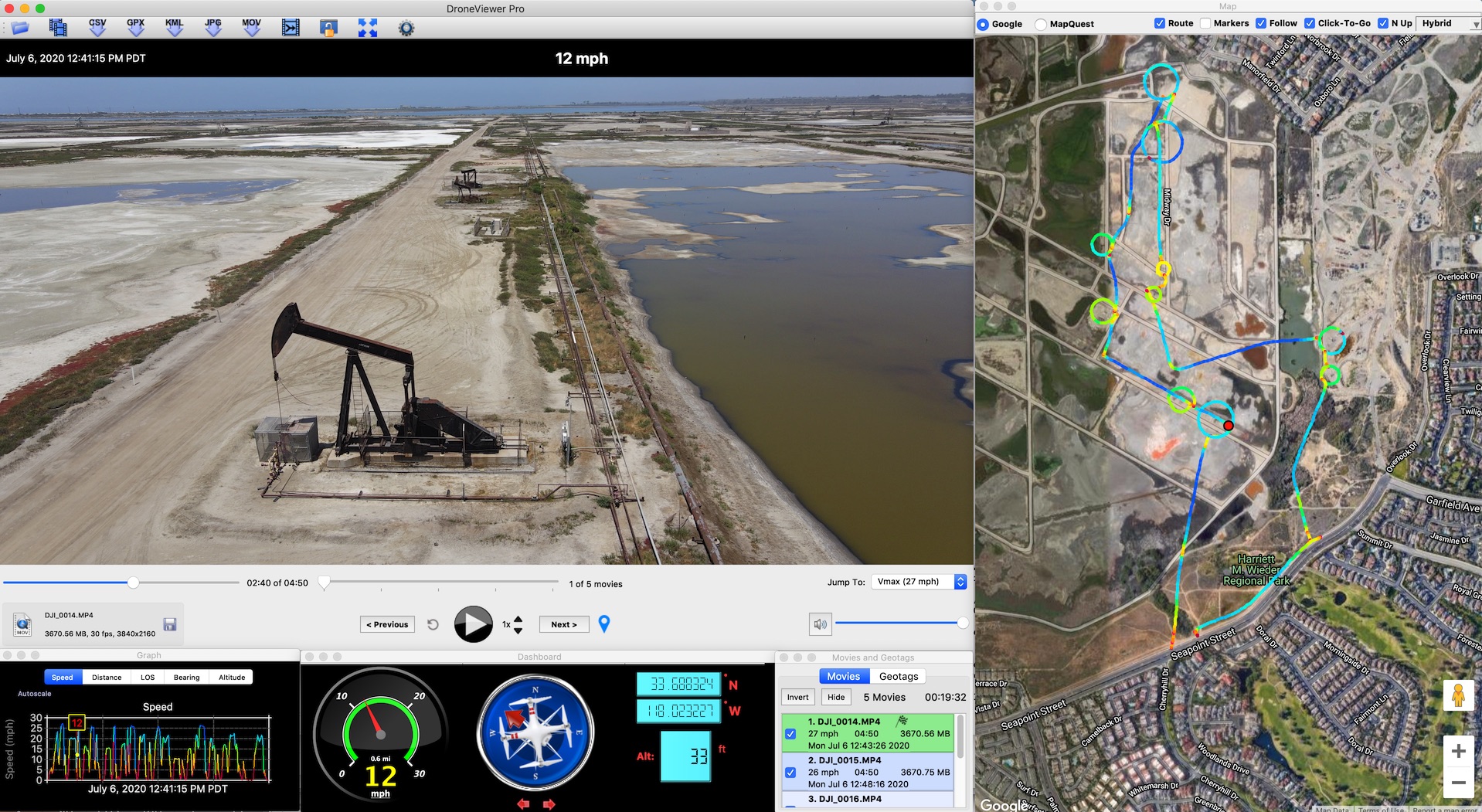
Mavic Air 2 video and data displayed in DroneViewer for site survey
DroneViewer is available for both Mac and Windows...
Similar threads
- Replies
- 4
- Views
- 863
- Replies
- 4
- Views
- 2K
- Replies
- 103
- Views
- 44K
- Replies
- 48
- Views
- 38K
DJI Drone Deals
New Threads
-
-
3 Second attempt to navigate coming clouds
- Started by alex_markov
- Replies: 0
-
-
-
Air 3 3 Features I Love About New DJI Drones
- Started by VegardBerland
- Replies: 3


