I am glad I could get that video showing the flight path ... I am sure a lot of readers of this thread were thinking "he was probably Hi and did not know where up/ down, left/ right was" ;-)
So yeah ... the drone was on a constant forward motion during the last 7 seconds.
I have a Theory ...
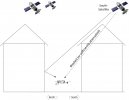
What if the signal from one of the GPS-satellites was reflected?
Let me explain what I mean:
GPS works in getting the distances from each of the satellites (in current view) and calculating the position of the receiver by triangulating the different satellite distances.
For my though-experiment I am assuming that only one satellite signal is being reflected. Let's assume it is that GPS-satellite that happened to be South (toward the back) of the drone.
If the drone receives a stronger reflected signal from that satellite in the South and moves North (As I was pushing the lever to go that way) it would see the distance to the South-Satellite become less. As the drone "thinks" it is too far South, it should even push the motors to go further North to correct the position. It will continue to do that as long as the reflected signal is stronger than the direct signal from the satellite ... until it crashes into the wall.
Unfortunately I have no idea how to prove (or disprove) this theory as these satellites zip all over the place, and you never know where one or more of them are (in view).
Just from my day-work dealing with WiFi-"issues" all the time, I know that "Low-E" windows with the metal substrate do absorb and reflect RF signals pretty good. With the GPS signal of around 1.2-1.6GHz it is fairly close to the 2.4GHz and 5GHz used by WiFi, so I think it is possible those RF-signals can get reflected in a similar way.
The location where the drone crashed is also between my house and the neighbors house ... about 8 meters (26ft) apart. They are both 2 story houses. My neighbors house could have blocked the signal, and on my house there was a window right where the drone crashed ... and also on the second floor is one.
If the drone calculates the xSpeed from the GPS-signals, this would explain why the log shows the movement toward South/ backwards ... as the drone "thought" it went that way.
I am not even asking for "plausible", but does anyone think this is a "possible" explanation?
When I look at the latitude information of the log, I do see the value decrease constantly in the last 3-4 seconds (except for the last 2 entries), but it only happened on the 6th digit after the decimal ... that's all below the accuracy of GPS (which should be around 1m).


