Hi,
Can anyone confirm that the Air writes full geotags with decimal seconds in JPEG images? The Spark was a huge disappointment because the geotags that it writes are truncated which makes it almost useless for photogrammetry. (The Spark does not record decimal seconds in JPEG images.)
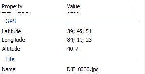
From Windows Explorer file properties, here's the crippled GPS information from a Spark image:

And this is the GPS data from the Mavic Pro image:

Thanks!
-Donald
Can anyone confirm that the Air writes full geotags with decimal seconds in JPEG images? The Spark was a huge disappointment because the geotags that it writes are truncated which makes it almost useless for photogrammetry. (The Spark does not record decimal seconds in JPEG images.)
From Windows Explorer file properties, here's the crippled GPS information from a Spark image:
And this is the GPS data from the Mavic Pro image:
Thanks!
-Donald