DJI Mavic, Air and Mini Drones
Friendly, Helpful & Knowledgeable Community
Join Us Now

Question about Air Map

PropSpin

Well-Known Member
Joined
Nov 27, 2018
Messages
402
Reactions
191
Location
Virginia - Eastern part
I used both Air Map and B4UFly recently while on vacation and noticed that Air Map did not show two helipads that were within 5 miles of my flying location. B4UFly did show them.

Any idea why Air Map didn't show the helipads?

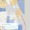
Also, Air Map had a white rectangle outlining a fairly large area (several hundred square miles) over the area I was at (Kitty Hawk, NC). Any idea what the rectangle is there for?
 
Air Map online shows this "Custom" area for Nags Head with special instructions. Can't say anymore about it because I've not seen any "custom areas" before.
72286

72287
 
  • Like
Reactions: BigAl07
Nags Head has their own ordnance, but I was miles away from there - just outside the 5 mile limit for the airport in Kill Devil Hills. Even up there, I saw that the special advisory for Nags Head was showing up. Either way, the huge rectangle for the small municipality of Nags Head doesn't make any sense to me.
Also doesn't make sense that it didn't show the helipads, not to mention that the circles around the airports were only around 2.5 miles in diameter versus the two concentric circles shown on your screenshot. I guess we were using different versions? I thought mine was up to date, maybe not.
 
It could be because you have selected different rules to fly under. If I select “fly for fun” on AirMap, I get very different results than if I select Part 107 (which I believe is what you have selected).
 
Nags Head has their own ordnance, but I was miles away from there - just outside the 5 mile limit for the airport in Kill Devil Hills. Even up there, I saw that the special advisory for Nags Head was showing up. Either way, the huge rectangle for the small municipality of Nags Head doesn't make any sense to me.
Also doesn't make sense that it didn't show the helipads, not to mention that the circles around the airports were only around 2.5 miles in diameter versus the two concentric circles shown on your screenshot. I guess we were using different versions? I thought mine was up to date, maybe not.
These programs (Air Map, Go4, B4UFly) all show different things, depending on which operating mode is selected, which is a major problem. I just looked at Air Map and it doesn't show any of the heliports/pads around me. I'm 2.5 miles from a hospital that has a helo based at it, and there are flights in and out all the time. It doesn't show up on Air Map as an aviation facility. However, it does show up this blob, which when clicked on identifies it by name as the hospital. I just checked as recreational, 107 and 333 and the status stays the same. It's located within Class D airspace of a nearby airport which is why the surrounding area is shaded.
72329
 
The inconsistency is amazing. On the other side of this I got a warning that I was in or near some sort of safety zone whilst flying at a soccer field in a nearby park. From Airmap near as I can tell it was for an ad hoc "helipad" that would get set up in an emergency. I think I have seen it used once in 25 years for a medevac for a traffic accident.
 
I use B4UFLY and AirMap. Both show my location as just within 5 miles of a Regional Airport. Hover shows that I’m outside 5 miles. I know this area well. Hover is correct. The other two are wrong.
 
I use B4UFLY and AirMap. Both show my location as just within 5 miles of a Regional Airport. Hover shows that I’m outside 5 miles. I know this area well. Hover is correct. The other two are wrong.
Is your measurement from the center of the runway, the end of the runway, the tower, or the fence line? I’m not being a smart as, just wondering if that could be the difference in measurements.
 
Is your measurement from the center of the runway, the end of the runway, the tower, or the fence line? I’m not being a smart as, just wondering if that could be the difference in measurements.
Or statute vs nautical miles. 1 NM = 1.15 SM
 
These programs (Air Map, Go4, B4UFly) all show different things, depending on which operating mode is selected, which is a major problem. I just looked at Air Map and it doesn't show any of the heliports/pads around me.
AirMap used to show some heliports not far from where I live, but not anymore. Maybe they're not showing "helipads" anymore...
 
Why the change in the radius around airports? If I remember correctly, under "Fly for Fun", par 101E was 5 miles out, now it's roughly 1.3 miles. Did the rules change and I just missed it?
 
Is your measurement from the center of the runway, the end of the runway, the tower, or the fence line? I’m not being a smart as, just wondering if that could be the difference in measurements.
From the tower to my location is 5.7 miles. Still, I call the CT, though I really don’t have to. I consider a mutual courtesy for safety. ???
 
From the tower to my location is 5.7 miles. Still, I call the CT, though I really don’t have to. I consider a mutual courtesy for safety. ???
As of Friday that will likely not be done... unless you have a friend there.
 
I understand AirMap changed after the new statute was enacted last fall even though the regulations have not changed yet. Under the new statute, notifying airports (including heliports) within 5 miles is no longer required. If the heliport is not in controlled airspace, you are permitted to fly without authorization or notification.
 

DJI Drone Deals

New Threads

Forum statistics

Threads
131,134
Messages
1,560,191
Members
160,105
Latest member
anton13