DJI Mavic, Air and Mini Drones
Friendly, Helpful & Knowledgeable Community
Join Us Now

Would someone please explain how to work around the DJI NFZ confusion?

Alright here is the .dat file for this flight. I havent much experience looking at these but it shows AIRPORT_AVOID_LANDING but airportlimit and vertAirportlimit=false. And notice the flycState at the end = FORCE_LANDING. I didnt even know that was a thing!

If you guys that look at these a lot and know what to look for it would be much appreciated. @sar104 I know you've seen a thing on two on these. Could you please take a peek?

Thanks guys!

Dat file 3-4-19 - Google Drive
 
Last edited:
Alright here is the .dat file for this flight. I havent much experience looking at these but it shows AIRPORT_AVOID_LANDING but airportlimit and vertAirportlimit=false. And notice the flycState at the end = FORCE_LANDING. I didnt even know that was a thing!

If you guys that look at these a lot and know what to look for it would be much appreciated. @sar104 I know you've seen a thing on two on these. Could you please take a peek?

Thanks guys!

Dat file 3-4-19 - Google Drive

There's all kinds of strange stuff going on in this flight - it's going to take me a while to go through it. Are you running some kind of hacked firmware?
 
  • Like
Reactions: brett8883
It's one thing when our government types impose rules and restrictions on us but who gives DJI the right to stick their noses into something that they have zero authority to do.
What gives them the right is that as the manufacturer they can design their products any way they want to. DJI has a vested business interest in not having its products banned because of owners flying them in restricted areas.
 
I am at work, so I can't dig up coordinates here, but I was at

18435 Townsend house dr Dade city, Florida 33523

I really just want to fly and get on the spot clearance easily. I've done it with a credit card before, but I couldn't even get to that screen. I am disappointed that these simple questions turned my thread into a macho pissing match, but I'm not gonna cry if you don't care or want to try to help.
 
  • Like
Reactions: Riteguy
I have flown a MP for years and have enjoyed the **** out of it; however, the fun is being drained away due to the unpredictable and, obviously, unavoidable DJI NFZ. I was driving along miles and miles of cow pastures and came across a beautiful meadow with a spectacular sunset about to happen. I was not within 20 miles of an airport or government safe house or a large group of people or area 52 or POTUS, but I was not allowed to take off due to a nfz.

Would someone please explain why I can get Clearance to fly near my house 5 miles from Tampa airport but not over cow dung in a remote meadow? Also, what can I do on the spot to work around these ******************* restrictions?

Thank you sincerely,

Denis(Soon to be an ex dji customer)
There are many YTs on the process.
 
There's all kinds of strange stuff going on in this flight - it's going to take me a while to go through it. Are you running some kind of hacked firmware?

Yea it’s all hacked up so I’ve changed all kinds of parameters and everything but I haven’t changed anything in a long time and It’s never once done something like this. I appreciate you taking the time to look at it!
 
Oh, probably not the answer you wanted to hear. Ever since I bricked a CoolPix camera installing some hacked firmware, I’ve vowed never to do something like that again. I hope that’s not the case for OP either.
 
Oh, probably not the answer you wanted to hear. Ever since I bricked a CoolPix camera installing some hacked firmware, I’ve vowed never to do something like that again. I hope that’s not the case for OP either.

I’ve now flown a few times since and everything is fine now. Switching to Litchi from DJI Go 4 seemed to have unlocked it from what ever was happening. Maybe it was a DJI Go bug or something?
 
  • Like
Reactions: AMann
I am at work, so I can't dig up coordinates here, but I was at

18435 Townsend house dr Dade city, Florida 33523

I really just want to fly and get on the spot clearance easily. I've done it with a credit card before, but I couldn't even get to that screen. I am disappointed that these simple questions turned my thread into a macho pissing match, but I'm not gonna cry if you don't care or want to try to help.

What I and many other people have done is altered the firmware on our drones to bypass the DJI limitations altogether for various reasons because, as you are finding it’s one thing to get the clearance from the proper authorities in your area and quite another to get the limitation removed by DJI. Do you want help in modifying your drone so that you don’t need to deal with the DJI side of things all together or are you trying to find help navigating DJIs complex and archaic system for NFZ unlocking?
 
  • Like
Reactions: Timhurlbut
All Federal Wilderness Areas have had aircraft flight guidelines, since first designated in the 70"s, long before drones became popular. Below is an excerpt from the following Google link: Section 4. Bird Hazards and Flight Over National Refuges, Parks, and Forests. According to this guidance, If an aviation chart shows a "Wilderness Area" this is the guidance for ALL aircraft types, not just drones.

7-4-6. Flights Over Charted U.S. Wildlife Refuges, Parks, and Forest Service Areas
a.
The landing of aircraft is prohibited on lands or waters administered by the National Park Service, U.S. Fish and Wildlife Service, or U.S. Forest Service without authorization from the respective agency. Exceptions include:
1. When forced to land due to an emergency beyond the control of the operator;
2. At officially designated landing sites; or
3. An approved official business of the Federal Government.
b. Pilots are requested to maintain a minimum altitude of 2,000 feet above the surface of the following: National Parks, Monuments, Seashores, Lakeshores, Recreation Areas and Scenic Riverways administered by the National Park Service, National Wildlife Refuges, Big Game Refuges, Game Ranges and Wildlife Ranges administered by the U.S. Fish and Wildlife Service, and Wilderness and Primitive areas administered by the U.S. Forest Service.
NOTE-
FAA Advisory Circular AC 91-36, Visual Flight Rules (VFR) Flight Near Noise-Sensitive Areas, defines the surface of a national park area (including parks, forests, primitive areas, wilderness areas, recreational areas, national seashores, national monuments, national lakeshores, and national wildlife refuge and range areas) as: the highest terrain within 2,000 feet laterally of the route of flight, or the upper-most rim of a canyon or valley.

c. Federal statutes prohibit certain types of flight activity and/or provide altitude restrictions over designated U.S. Wildlife Refuges, Parks, and Forest Service Areas. These designated areas, for example: Boundary Waters Canoe Wilderness Areas, Minnesota; Haleakala National Park, Hawaii; Yosemite National Park, California; and Grand Canyon National Park, Arizona, are charted on Sectional Charts.
d. Federal regulations also prohibit airdrops by parachute or other means of persons, cargo, or objects from aircraft on lands administered by the three agencies without authorization from the respective agency. Exceptions include:
1. Emergencies involving the safety of human life; or
2. Threat of serious property loss.

To add further insight regarding the above information and the difference between "requested" and "prohibit, I recommend checking out this link: The Rules about Flying over Wilderness Areas.

It is easy to miss some of these apparently obscure and confusing rules if you don't fly actual airplanes or helicopters, or have not worked for a natural resource agency that deals with this topic regularly. I fly both types of aircraft, plus drones, and have also worked professionally for several natural resource agencies (both State and Federal). While DJI has been a little too ambitious, at times, with some of the restrictions, they are simply trying to head off all the many entities trying to shut down drone flyers by limiting conflicts through built in flight restrictions in the software.

It is possible, from the second link I provided, that DJI has gone the extra mile here in ensuring no conflict with Wilderness users, perhaps overly restricting in this particular area, since there are no flight restrictions printed on the chart, only the guidance provided in Chapter 7 of the Airman's Information Manual (AIM). So in this case it appears DJI has taken the conservative route and has the built in restriction, when it appears to be only a "requested" guideline.

You can argue they should not impose their ethics on us as flyers, but at the same time, they see the bigger picture and future sales of drones. They know you don't win by clashing with the Wilderness user! Since they are the world's largest drone supplier, it makes sense for them to take the lead in being overly conservative. Perhaps other competitive drone makers see that as a way to get their toe into DJI's business, by not being so careful, maybe even breaking some rules? I see DJI as being very wise in their long term strategy.

I have personally run into some of these surprise restrictions when I did not expect it, and even felt it went overboard, but I still think the strategy is sound, whether I liked it or not! So, I just made the adjustment. I even plan annual vacations on where I "can" fly, not where I "can't. I made a solo trip on a houseboat on Rainy Lake in 2017 but due to drone restrictions by Voyageurs National Park, I did not return, instead I rented a small houseboat in 2018 on Lake Temagami in NE Ontario, which is not a National Park or Wilderness Area where I could fly my drone. I had so much fun, I'm going back again this year!
 
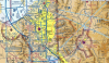
looks like you were in Class C mode C airspace.
 

Attachments

  • class C.PNG
    class C.PNG
    3.2 MB · Views: 49
  • mode C.PNG
    mode C.PNG
    17.9 KB · Views: 48
You are way too far north there but thanks for looking!
Never mind it must have zoomed in when I looked at it.

Where do you see it says class c? And the airport is more than 20 miles away. It seems to me if that’s the case you can’t fly anywhere in a city and if you go outside the city you hit wilderness areas. Might as well start flying a skull and cross bones on my drone because it’s impossible to follow the rules

It's not Class C - it's Class G. It is inside the Mode C veil, which may be the source of the confusion:

1551899701640.jpeg
 
1. He was not in Class C airspace, as sar104 points out.
2. Mode C is not airspace, it's where an aircraft has to be equipped with and transmitting a transponder code, which is irrelevant to sUAS.
 
  • Like
Reactions: dawgpilot

DJI Drone Deals

New Threads

Forum statistics

Threads
131,321
Messages
1,561,998
Members
160,259
Latest member
smittysflying