You know that feeling when you're about to ask a question that has a totally obvious answer that two days of playing with VLM has hidden from you? That's me!
a) Should the flight time in GE be the same(ish) as that shown at the top of Litchi Hub? Mine never are … GE is always a lot longer,
… and ...
b) Should the Cruise Speed be represented correctly in VLM (as it is in calculating that Litchi Hub flight time) because, with ALL WPs set to Cruise Speed I can still change the mission settings value, Mission Hub reflects that change, but almost no change is perceived in GE.
PS - this software is awesome! When those problems are sorted it will be a lot more awesomererer!
There are a few things to understand about cruising speed :
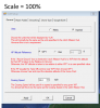
1) The csv file output by Litchi unfortunately does not contain the cruising speed which you set in the Litchi mission settings. If you examine the csv file you will see that a value of zero is output instead of the desired cruising speed. This means that in order to get a virtual flight which matches the real deal you need to tell VLM the cruising speed. You should set the cruising speed in VLM to be the same as the cruising speed set in Ltichi.
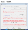
2) This issue goes away if you explicitly specify the speed for each leg of your mission. In this case the cruising speed is not used and VLM should fly the mission at the correct speed for each leg.
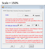
3) As you have noticed, the flight times calculated by VLM and shown in the Activity Log are often not the same as the flight times calculated by Litchi. I think if you do the arithmetic yourself with a calculator you will find that the VLM figures are correct.
4) A number of people have compared virtual missions with their real flights and they are generally pretty good all things considered. For example, in post 588 on this thread, Prismatic found a speed correction factor of 0.996!!
Hope this answers your questions
N
Last edited:


") )
)