1) Open your mission using the VLM Mission Hub Panel.
2) Then "Export as CSV" so that VLM performs the calculations and generates the smooth flightpath
3) Download the CSV file from Airdata into your watchfolder. VLM will the detect it, recognise it as an Airdata file and compare it with the planned flight path produced in 2). Some simple statistics are then produced in the Activity Log.
N
Namirda, It looks like this worked as you intended but I have a question as a result.
The csv file from airdata may be incomplete if your mission took the drone out of RC range for a moment or so. That would seem to affect the calculations in differences between the files.
Now that airdata is beta testing output csv files based on a user uploading the DJI .dat file, the new csv file contains the full flight data (since it came from the drone).
Would you consider being able to read that file instead? I have a few of them converted.
PS, I don't think Airdata widely advertised this yet but the notified a handful of users (myself included) because we had been pushing for this. It works exceedingly well!
(This started over a year ago when some of my flights had missing telemetry due to RC disconnects and I asked them about it as a feature request.)
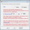
The comparison between the Airdata csv file (which usually contains thousands of points) and the VLM Smoothed Path is performed as follows:
1) Starting at the beginning of the AirData file, I find the point which is nearest to the first VLM waypoint and record its distance from the waypoint as well as the difference in gimbal, heading and elevation.
2) I then progress through the Airdata file until I reach the Airdata point which is nearest to the second VLM waypoint and record the same differences as above.
3) Rinse and repeat until all VLM waypoints have been handled.
4) Calculate simple statistics.
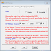
It looks as if you have a very good match - your real flight had an average horizontal difference of only 0.48m with a standard deviation of 0.4m
and a vertical difference of 0.57m with a SD of almost nothing. Clearly I have some bug in my calculation of gimbal and heading values - or perhaps your drone was going out of range?
I originally wrote this little module as a diagnostic tool for myself to check that VLM was performing as it should - I never really thought it would have any value for users. Does it?
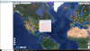
If you want to compare the real and planned missions you can easily import the kml from Airdata and overlay it on top of the VLM Smoothed flight path in GE for an immediate visual comparison. Did you do that?
N
")

")