DJI Mavic, Air and Mini Drones
Friendly, Helpful & Knowledgeable Community
Join Us Now

Virtual Litchi Mission

Results are the same. The gimbel warnings are gone but the altitude warnings are there. The altitude is still way higher than what is set the the program.

I did another run with different altitude (150), different waypoints and different POIs. The results are the same, 4000 feet above ground level. I did another with the "above ground" box unchecked and it did not change the altitude. This is just baffling.

Interestingly I have a number of other missions, several of which that I have run and all of those originally showed the correct altitude on GE when opened. For instance, one had an altitude of 100 feet. It opened on GE at the proper altitude IN THE PAST, and when run in real life performed as it should. It now transfers to GE with the exaggerated altitudes. I am thinking of dropping back to the last version of VLM to see if that is the problem.
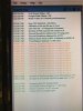
I don't think the previous version of VLM will help... You might want to reset VLM to its initial conditions by pressing CTRL while you start it.

I would like to see the complete Activity Log from the VLM run of your mission. And the GE result - remember to clear your "temporary Places" first.

Thanks
 
Same results less many of the warnings.
 

Attachments

  • IMG_1145.jpg
    IMG_1145.jpg
    78.9 KB · Views: 14
  • IMG_1146.jpg
    IMG_1146.jpg
    96.7 KB · Views: 14
namirda, is it possible to take a csv file (from a previous actual flight in Airdata UAV) and import/load that into VLM? I'm curious because I'd like to know what the real flight would look like represented in Google Earth. I tried file, load and then tried to load a csv from Airdata UAV but it didn't work.
 
Same results less many of the warnings.

Your VLM log is showing a WP1 elevation of 4620.9ft which is the same as I get - I don't understand how this can result in different results in GE.

1) I'm puzzled by all those warnings about excessive elevation change. Do you have Drone Type set to Mavic in VLM?
2) Did you try resetting VLM to initial conditions (CTRL on startup)

N
 
Another question. Has the ability to keep the exported Mission Hub file been disabled? I've changed the tick button to keep the file instead of delete it but it's never in the watch folder. I've changed the watch folder to another local folder, exited, relaunched and tried again but it's always not there as if the tick box to delete it was ticked on. Ideas?
 
Drone type is set to mavic air. I did a reset at startup and got the same results.

I don't understand it either. And now all of my missions have fallen into that altitude issue. They were fine before I tried to import them to Google Earth for a virtual run.
 
namirda, is it possible to take a csv file (from a previous actual flight in Airdata UAV) and import/load that into VLM? I'm curious because I'd like to know what the real flight would look like represented in Google Earth. I tried file, load and then tried to load a csv from Airdata UAV but it didn't work.

Two options:

1) Export the kml from Airdata into the VLM watchfolder. VLM will pick it up and pass it on to Google Earth.

2) The next option is an un documented feature of VLM which I never really completed. If you export the CSV from AirData into the VLM watchfolder then VLM will compare that with the current CSV file and produce some simple statistics. My idea was to get some idea how accurately the drone had flown the planned mission. You must export the original CSV file from the Litchi Mission Hub first and then download the CSV file from Airdata. If the two missions (planned and actual) do not match then you will get an error. I did not really finish up this part of VLM because I am not sure how useful it is. Take a look and let me know what you think.

N
 
  • Like
Reactions: marklyn
Two options:

1) Export the kml from Airdata into the VLM watchfolder. VLM will pick it up and pass it on to Google Earth.

2) The next option is an un documented feature of VLM which I never really completed. If you export the CSV from AirData into the VLM watchfolder then VLM will compare that with the current CSV file and produce some simple statistics. My idea was to get some idea how accurately the drone had flown the planned mission. You must export the original CSV file from the Litchi Mission Hub first and then download the CSV file from Airdata. If the two missions (planned and actual) do not match then you will get an error. I did not really finish up this part of VLM because I am not sure how useful it is. Take a look and let me know what you think.

N
Ahhh. that's where I was going with this, to compare the two.
I must not be doing something right on #2. I opened the mission hub file for the flight in VLM then I exported/saved the same flight from mission hub to the same watch folder. I get the error "No Litchi csv file available for comparison with this Airdata file".
I'm guessing not many users would care about this but I'm glad to know you were trying to work something like this out.
 
Last edited:
Another question. Has the ability to keep the exported Mission Hub file been disabled? I've changed the tick button to keep the file instead of delete it but it's never in the watch folder. I've changed the watch folder to another local folder, exited, relaunched and tried again but it's always not there as if the tick box to delete it was ticked on. Ideas?

The option whether or not to delete the csv file only applies to files downloaded to the watchfolder from outside of VLM. CSV files which are generated from the Mission Hub panel of VLM are always deleted.

N
 
Last edited:
Ahhh. that's where I was going with this, to compare the two.
I must not be doing something right on #2. I opened the mission hub file for the flight in VLM then I exported/saved the same flight from mission hub to the same watch folder. I get the error "No Litchi csv file available for comparison with this Airdata file".
I'm guessing not many users would care about this but I'm glad to know you were trying to work something like this out.

1) Open your mission using the VLM Mission Hub Panel.
2) Then "Export as CSV" so that VLM performs the calculations and generates the smooth flightpath
3) Download the CSV file from Airdata into your watchfolder. VLM will the detect it, recognise it as an Airdata file and compare it with the planned flight path produced in 2). Some simple statistics are then produced in the Activity Log.

On another issue, if you have a minute or two, could you please take a quick look at the mission which CAG posted in a recent post. It works perfectly for me but he has altitude problems which I cannot get to the bottom of. Can you let me know if the VLM mission looks OK for you.

Thanks

N
 
Last edited:
  • Like
Reactions: marklyn
1) Open your mission using the VLM Mission Hub Panel.
2) Then "Export as CSV" so that VLM performs the calculations and generates the smooth flightpath
3) Download the CSV file from Airdata into your watchfolder. VLM will the detect it, recognise it as an Airdata file and compare it with the planned flight path produced in 2). Some simple statistics are then produced in the Activity Log.

On another issue, if you have a minute or two, could you please take a quick look at the mission which CAG posted in a recent post. It works perfectly for me but he has altitude problems which I cannot get to the bottom of. Can you let me know if the VLM mission looks OK for you.

Thanks

N
Thanks for that, I will try that tomorrow morning.
As for CAG's mission I exported it and it looked exactly like yours did, normal.
However, I futzed with the properties on the smooth flight plan and changed the altitude to a couple thousand meters and it looked very close to what he showed. Some setting in that area in GE maybe?
 
Namirda, I followed your directions closely (results below)... So the results below show differences in the planned mission vs the actual flight, I'm interested in the gimbal error...


8:27:41 AM New CSV File detected in WatchFolder
File Name is E:\vlm\2018-09-09_15-56-34_Standard.csv
8:27:41 AM AirData File OK - 4304 Waypoints Processed
8:27:41 AM Mean Distance Error = 0.4892967 SD = 0.4050325
8:27:41 AM Mean Elevation Error = 0.5793512 SD = 0.0923856
8:27:41 AM Mean Heading Error = -909.7481 SD = 41.86573
8:27:41 AM Mean Gimbal Error = -1035.612 SD = 7.298592
 
Namirda, It looks like this worked as you intended but I have a question as a result.
The csv file from airdata may be incomplete if your mission took the drone out of RC range for a moment or so. That would seem to affect the calculations in differences between the files.
Now that airdata is beta testing output csv files based on a user uploading the DJI .dat file, the new csv file contains the full flight data (since it came from the drone).
Would you consider being able to read that file instead? I have a few of them converted.
PS, I don't think Airdata widely advertised this yet but the notified a handful of users (myself included) because we had been pushing for this. It works exceedingly well!

(This started over a year ago when some of my flights had missing telemetry due to RC disconnects and I asked them about it as a feature request.)
 
Some setting in that area in GE maybe?

That has been my thought all along. The problems started when I first tried to use GE to fly the mission and it now has changed other missions that were otherwise fine when displayed in GE. Once I tried to fly them it messes up.
 
  • Like
Reactions: marklyn
CAG, I didn't look through all of the other threads, but did you try uninstalling GE, rebooting, re-installing GE?
Maybe VLM too, just to be sure.
Also, do you have another pc/laptop you can install GE & VLM on to test it out?
If it runs consistently well on a new pc/laptop install then there must be something on your pc causing the issue.
If that ends up to be the case you may have to dig Google Earth out of the registry to ensure all settings are removed, possibly even in the c:/username/appdata... folders too.
 
I tried the uninstall and reinstall of GE but not VLM. I can give that a try. I have a registry cleaner that will remove all of the left over junk once a program is uninstalled and I will give that a try also. I do have a laptop that I use in the field for missions and I will run it there and see what happens. Report later today. Thanks for the suggestions. I was just thinking about getting into the registry for another issue (get rid of Bing) so I may do both.
 
  • Like
Reactions: marklyn
I tried the uninstall and reinstall of GE but not VLM. I can give that a try. I have a registry cleaner that will remove all of the left over junk once a program is uninstalled and I will give that a try also. I do have a laptop that I use in the field for missions and I will run it there and see what happens. Report later today. Thanks for the suggestions. I was just thinking about getting into the registry for another issue (get rid of Bing) so I may do both.
There's not much in the regular part of the registry for Google Earth (local machine) but I suspect there are other places in the registry.
I also think it would be good to remove GE and go into the C:\Users\username\AppData\LocalLow\Google\GoogleEarth and remove those folders before reinstalling.
There is also a Namirda folder here: C:\Users\username\AppData\Local\Namirda
I don't know if deleting that will make a difference, I'm just using a sledgehammer approach to get your system to the way it was before VLM and GE touched it to see if that helps.
 
Sit Rep: It runs find on my laptop. I am going back thru the uninstall and reinstall on the desktop as you suggested above.

OK. This is just mind blowing. I went through a total uninstall of all related files for both GE and VLM. I rebooted and reinstalled both programs. It still runs missions at the wrong altitude. When I compare the mission activity log on the laptop, which runs correctly and the desktop which does not, they are exactly the same. I have one orange warning in both. It is the same warning of an excessive altitude change.
 
Last edited:
What happens if you export only the KML file from Mission Hub and import that into GE? Does it appear at the correct altitude?
 
It did before I started using CVS to move them. Then I went back to see the KML and it was wrong too. Something, somewhere is converting them and leaving them that way. It is just my desktop. The laptop is fine.

I am editing some of these rather than continuing to post in different messages and lengthen this out.

I did just get a message when I tried to send it to KML that I have not gotten before and do not know where that setting might be:
"Please enable Elevation Featues in the Hub settings to use this feature." Where would that be? I don't find it.
 
Last edited:
Lycus Tech Mavic Air 3 Case

DJI Drone Deals

New Threads

Forum statistics

Threads
131,125
Messages
1,560,087
Members
160,099
Latest member
tflys78