DJI Mavic, Air and Mini Drones
Friendly, Helpful & Knowledgeable Community
Join Us Now

Virtual Litchi Mission

I don't know what the limit is on Litci, or if there is a limit at all, but look at the image I can create more than 250

View attachment 162331
Hum, I create all in Litchi, then use VLM to transfer to GEP, so this is long thread, I think we should wait for somebody tell us. I will take a look here. Litchi Forum
I do recommend that if your going to use this forum a lot. Do this part.
The members here are awesome!

Rod
 
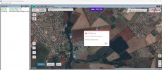
When I try to create a Grid Mission for a large area, the VLM limits me to 250 pois
Here you are asking about a limit on POIs.

I don't know what the limit is on Litci, or if there is a limit at all, but look at the image I can create more than 250
Now you are showing a mission with waypoints.

It's confusing but you appear to be asking about the maximum number of "Waypoints", not "POIs".

Litchi used to be limited to 99 waypoints because that was the limit in the number of waypoints that could be uploaded to DJI drones. However, since more recent DJI drones use virtual-sticks, they no longer have a 99-waypoint limit. As a result, Litchi increased the maximum number of waypoints on a single mission to be 10,000. Older DJI drones with firmware-supported waypoint missions will fly larger missions 99 waypoints at a time and then load the next batch of 99 waypoints until the mission is completed.

After Litchi increased the waypoint limit to 10,000, Namirda also increased the maximum number of waypoints his software could handle to 250 because that seemed to be a reasonable trade-off between what most missions require and memory requirements of his software.
 
  • Like
Reactions: RodPad
Here you are asking about a limit on POIs.


Now you are showing a mission with waypoints.

It's confusing but you appear to be asking about the maximum number of "Waypoints", not "POIs".

Litchi used to be limited to 99 waypoints because that was the limit in the number of waypoints that could be uploaded to DJI drones. However, since more recent DJI drones use virtual-sticks, they no longer have a 99-waypoint limit. As a result, Litchi increased the maximum number of waypoints on a single mission to be 10,000. Older DJI drones with firmware-supported waypoint missions will fly larger missions 99 waypoints at a time and then load the next batch of 99 waypoints until the mission is completed.

After Litchi increased the waypoint limit to 10,000, Namirda also increased the maximum number of waypoints his software could handle to 250 because that seemed to be a reasonable trade-off between what most missions require and memory requirements of his software.
What I meant is that on Litchi's website there are no limits, but on VLM the limit is 250.
See what happens when I try to create a mapping mission in a relatively small area.
Captura de tela 2023-04-06 130826.jpg
 
What I meant is that on Litchi's website there are no limits, but on VLM the limit is 250.
See what happens when I try to create a mapping mission in a relatively small area.

As you have discovered, it is very easy to create missions with a excessively large numbers of WPs when using the VLM Grid option.

When processing a mission, VLM retrieves the elevation of every WP and every POI from the Google Elevation API and there is a daily limit on how much elevation data can be retrieved without incurring charges from Google.

This daily data quota is shared between all users of VLM so if one user unintentionally creates a grid mission with a huge number of WPs it will affect all other users for the rest of the 24 hour period. I therefore felt it necessary to limit the size of grids to something reasonable - currently 250 points.

One solution is for VLM to allow grids of more than 250 points only if you provide your own Google API Key.

Any other suggestions?

N
 
  • Like
Reactions: RodPad
As you have discovered, it is very easy to create missions with a excessively large numbers of WPs when using the VLM Grid option.

When processing a mission, VLM retrieves the elevation of every WP and every POI from the Google Elevation API and there is a daily limit on how much elevation data can be retrieved without incurring charges from Google.

This daily data quota is shared between all users of VLM so if one user unintentionally creates a grid mission with a huge number of WPs it will affect all other users for the rest of the 24 hour period. I therefore felt it necessary to limit the size of grids to something reasonable - currently 250 points.

One solution is for VLM to allow grids of more than 250 points only if you provide your own Google API Key.

Any other suggestions?

N
I understand about the limitation now, and you were very consistent in limiting it to benefit all users.
Can you tell me how I could provide my own Google API key?
 
I understand about the limitation now, and you were very consistent in limiting it to benefit all users.
Can you tell me how I could provide my own Google API key?
This question has come up a few times before...

Take a look at this thread which gives some more background and tells you how to get your own key

N
 
  • Like
Reactions: RodPad
This question has come up a few times before...

Take a look at this thread which gives some more background and tells you how to get your own key

N
Namirda, thank you very much for the reply.
The problem is that, even using my credentials on google api, the VLM continues to limit it to 250 waypoints.
 
Namirda, thank you very much for the reply.
The problem is that, even using my credentials on google api, the VLM continues to limit it to 250 waypoints.
Hi,

Yes - because I have not yet updated the code.

In my earlier post I suggested that this may be a solution to your problem and asked for any other suggestions.

Nobody came with any alternative suggestions and so I will make the changes and upload a new version of VLM as soon as I find time.

N
 
  • Like
Reactions: RodPad
Virtual Litchi Mission V2.8.2 is now available for download.

The link can be found in the first post of this long thread.

The only change from V2.8.1 is that the maximum size of grid missions has been increased to 1000 waypoints for users who have supplied a private Google Elevation api key. If you do not provide a private key then the limit remains at 250 points.

I am reluctant to allow larger missions than 1000 waypoints - on my old PC it is already quite slow at 1000 points

If you are using your own api key, please monitor your usage carefully so that you do not end up with unexpected charges from Google.

N
 
  • Like
Reactions: maps4me
Virtual Litchi Mission V2.8.2 is now available for download.

The link can be found in the first post of this long thread.

The only change from V2.8.1 is that the maximum size of grid missions has been increased to 1000 waypoints for users who have supplied a private Google Elevation api key. If you do not provide a private key then the limit remains at 250 points.

I am reluctant to allow larger missions than 1000 waypoints - on my old PC it is already quite slow at 1000 points

If you are using your own api key, please monitor your usage carefully so that you do not end up with unexpected charges from Google.

N
Namirda, congratulations on your work!
I am very grateful.
Can you tell me what is the limit for using waypoints in the Google Elevation API before being charged?
 
Namirda, congratulations on your work!
I am very grateful.
Can you tell me what is the limit for using waypoints in the Google Elevation API before being charged?
I believe Google allow 40,000 API requests per month with no charge - and after that they will charge you $5 per thousand requests.

Note that each API request can contain multiple locations. VLM handles waypoints in chunks of 40 - so a mission of 100 waypoints would require 3 API requests.

N
 
  • Like
Reactions: RodPad
Can you tell me what is the limit for using waypoints in the Google Elevation API before being charged?
While it is unlikely that one person will make enough Google Elevation API requests that would exceed the free limit, you can place a quota on your usage such that you can never exceed that limit.

I use several Google APIs and have configured quotas on each to prevent any unexpected charges. Because navigating Google API dashboard can sometimes be less than intuitive, I have created documentation to help you navigate their dashboard and to set a quota.

Works here! Tks
 
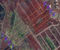
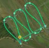
I'll show you how I usually do my flight missions to be able to map with the Mavic 3.
1 - In litchi, I draw the lines as waypoints, and when I reach the end of a line I create two close points so that the drone does not make very long curves. See the images below. The second image shows what happens if the next points at the end of each line are not created.
MAVIC3_MISSION_01.jpgMAVIC3_MISSION_03.jpg
2 - I export the mission to CSV
3 - I use the Litchi Waypoint Mission to Mavic 3 Waypoint Mission tool to convert the mission to a Waypoint kmz that is openable on the Mavic 3
4 - At the moment of executing the flight, I set the Mavic 3 to shoot photos every 3s

I made this post to try to help, as this would be a way to save on the use of waypoints

Guys, thank you very much, you are the best
 
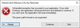
Today I constantly get this error when attempting to send a mission to Google Earth:
Capture.PNG

See the end of this message for details on invoking
just-in-time (JIT) debugging instead of this dialog box.

************** Exception Text **************
System.NotSupportedException: The given path's format is not supported.
at System.Security.Permissions.FileIOPermission.EmulateFileIOPermissionChecks(String fullPath)
at System.Security.Permissions.FileIOPermission.QuickDemand(FileIOPermissionAccess access, String fullPath, Boolean checkForDuplicates, Boolean needFullPath)
at Microsoft.VisualBasic.FileIO.FileSystem.NormalizePath(String Path)
at Microsoft.VisualBasic.FileIO.FileSystem.OpenTextFileWriter(String file, Boolean append, Encoding encoding)
at Virtual_Litchi_Mission.Module2.Prepare_KML()
at Virtual_Litchi_Mission.Form1.Litchi_GetMission()
at Virtual_Litchi_Mission.Form1.btnSend2GE_Click(Object sender, EventArgs e)
at System.Windows.Forms.ToolStripItem.RaiseEvent(Object key, EventArgs e)
at System.Windows.Forms.ToolStripButton.OnClick(EventArgs e)
at System.Windows.Forms.ToolStripItem.HandleClick(EventArgs e)
at System.Windows.Forms.ToolStripItem.HandleMouseUp(MouseEventArgs e)
at System.Windows.Forms.ToolStrip.OnMouseUp(MouseEventArgs mea)
at System.Windows.Forms.Control.WmMouseUp(Message& m, MouseButtons button, Int32 clicks)
at System.Windows.Forms.Control.WndProc(Message& m)
at System.Windows.Forms.ToolStrip.WndProc(Message& m)
at System.Windows.Forms.NativeWindow.Callback(IntPtr hWnd, Int32 msg, IntPtr wparam, IntPtr lparam)


************** Loaded Assemblies **************
mscorlib
Assembly Version: 4.0.0.0
Win32 Version: 4.8.9181.0 built by: NET481REL1LAST_C
CodeBase: file:///C:/Windows/Microsoft.NET/Framework64/v4.0.30319/mscorlib.dll
----------------------------------------
Virtual Litchi Mission
Assembly Version: 2.8.2.0
Win32 Version: 2.8.2
CodeBase: file:///C:/Program%20Files/Namirda/Virtual%20Litchi%20Mission/Virtual%20Litchi%20Mission.exe
----------------------------------------
Microsoft.VisualBasic
Assembly Version: 10.0.0.0
Win32 Version: 14.8.9037.0 built by: NET481REL1
CodeBase: file:///C:/WINDOWS/Microsoft.Net/assembly/GAC_MSIL/Microsoft.VisualBasic/v4.0_10.0.0.0__b03f5f7f11d50a3a/Microsoft.VisualBasic.dll
----------------------------------------
System
Assembly Version: 4.0.0.0
Win32 Version: 4.8.9172.0 built by: NET481REL1LAST_C
CodeBase: file:///C:/WINDOWS/Microsoft.Net/assembly/GAC_MSIL/System/v4.0_4.0.0.0__b77a5c561934e089/System.dll
----------------------------------------
System.Core
Assembly Version: 4.0.0.0
Win32 Version: 4.8.9181.0 built by: NET481REL1LAST_C
CodeBase: file:///C:/WINDOWS/Microsoft.Net/assembly/GAC_MSIL/System.Core/v4.0_4.0.0.0__b77a5c561934e089/System.Core.dll
----------------------------------------
System.Windows.Forms
Assembly Version: 4.0.0.0
Win32 Version: 4.8.9181.0 built by: NET481REL1LAST_C
CodeBase: file:///C:/WINDOWS/Microsoft.Net/assembly/GAC_MSIL/System.Windows.Forms/v4.0_4.0.0.0__b77a5c561934e089/System.Windows.Forms.dll
----------------------------------------
System.Drawing
Assembly Version: 4.0.0.0
Win32 Version: 4.8.9037.0 built by: NET481REL1
CodeBase: file:///C:/WINDOWS/Microsoft.Net/assembly/GAC_MSIL/System.Drawing/v4.0_4.0.0.0__b03f5f7f11d50a3a/System.Drawing.dll
----------------------------------------
System.Configuration
Assembly Version: 4.0.0.0
Win32 Version: 4.8.9037.0 built by: NET481REL1
CodeBase: file:///C:/WINDOWS/Microsoft.Net/assembly/GAC_MSIL/System.Configuration/v4.0_4.0.0.0__b03f5f7f11d50a3a/System.Configuration.dll
----------------------------------------
System.Xml
Assembly Version: 4.0.0.0
Win32 Version: 4.8.9037.0 built by: NET481REL1
CodeBase: file:///C:/WINDOWS/Microsoft.Net/assembly/GAC_MSIL/System.Xml/v4.0_4.0.0.0__b77a5c561934e089/System.Xml.dll
----------------------------------------
System.Runtime.Remoting
Assembly Version: 4.0.0.0
Win32 Version: 4.8.9037.0 built by: NET481REL1
CodeBase: file:///C:/WINDOWS/Microsoft.Net/assembly/GAC_MSIL/System.Runtime.Remoting/v4.0_4.0.0.0__b77a5c561934e089/System.Runtime.Remoting.dll
----------------------------------------
CefSharp.WinForms
Assembly Version: 99.2.90.0
Win32 Version: 99.2.90.0
CodeBase: file:///C:/Program%20Files/Namirda/Virtual%20Litchi%20Mission/CefSharp.WinForms.DLL
----------------------------------------
CefSharp
Assembly Version: 99.2.90.0
Win32 Version: 99.2.90.0
CodeBase: file:///C:/Program%20Files/Namirda/Virtual%20Litchi%20Mission/CefSharp.DLL
----------------------------------------
Newtonsoft.Json
Assembly Version: 13.0.0.0
Win32 Version: 13.0.1.25517
CodeBase: file:///C:/Program%20Files/Namirda/Virtual%20Litchi%20Mission/Newtonsoft.Json.DLL
----------------------------------------
System.Numerics
Assembly Version: 4.0.0.0
Win32 Version: 4.8.9037.0 built by: NET481REL1
CodeBase: file:///C:/WINDOWS/Microsoft.Net/assembly/GAC_MSIL/System.Numerics/v4.0_4.0.0.0__b77a5c561934e089/System.Numerics.dll
----------------------------------------
CefSharp.Core
Assembly Version: 99.2.90.0
Win32 Version: 99.2.90.0
CodeBase: file:///C:/Program%20Files/Namirda/Virtual%20Litchi%20Mission/CefSharp.Core.DLL
----------------------------------------
CefSharp.Core.Runtime
Assembly Version: 99.2.90.0
Win32 Version: 99.2.90
CodeBase: file:///C:/Program%20Files/Namirda/Virtual%20Litchi%20Mission/CefSharp.Core.Runtime.DLL
----------------------------------------
System.Web.Extensions
Assembly Version: 4.0.0.0
Win32 Version: 4.8.9181.0
CodeBase: file:///C:/WINDOWS/Microsoft.Net/assembly/GAC_MSIL/System.Web.Extensions/v4.0_4.0.0.0__31bf3856ad364e35/System.Web.Extensions.dll
----------------------------------------
System.Web
Assembly Version: 4.0.0.0
Win32 Version: 4.8.9181.0 built by: NET481REL1LAST_C
CodeBase: file:///C:/WINDOWS/Microsoft.Net/assembly/GAC_64/System.Web/v4.0_4.0.0.0__b03f5f7f11d50a3a/System.Web.dll
----------------------------------------
System.Xml.Linq
Assembly Version: 4.0.0.0
Win32 Version: 4.8.9037.0 built by: NET481REL1
CodeBase: file:///C:/WINDOWS/Microsoft.Net/assembly/GAC_MSIL/System.Xml.Linq/v4.0_4.0.0.0__b77a5c561934e089/System.Xml.Linq.dll
----------------------------------------
Accessibility
Assembly Version: 4.0.0.0
Win32 Version: 4.8.9037.0 built by: NET481REL1
CodeBase: file:///C:/WINDOWS/Microsoft.Net/assembly/GAC_MSIL/Accessibility/v4.0_4.0.0.0__b03f5f7f11d50a3a/Accessibility.dll
----------------------------------------

************** JIT Debugging **************
To enable just-in-time (JIT) debugging, the .config file for this
application or computer (machine.config) must have the
jitDebugging value set in the system.windows.forms section.
The application must also be compiled with debugging
enabled.

For example:

<configuration>
<system.windows.forms jitDebugging="true" />
</configuration>

When JIT debugging is enabled, any unhandled exception
will be sent to the JIT debugger registered on the computer
rather than be handled by this dialog box.
 
Today I constantly get this error when attempting to send a mission to Google Earth:

View attachment 168820
Hi,

VLM is still working for me - anybody else having this problem?

I'm not sure but I think the problem may be something to do with an incorrect temp file setting for your windows user. VLM writes the kml file to your temp folder and is having some problems doing so.

To check this, open the search utility and enter %temp% which will open your temp folder.

The default location for this folder is c:\users\<user>\Appdata\local\temp

If it is something different on your system then that might be your problem. Either reset the temp folder back to the default using the "environment variables" option in control panel/system or try another user.

Let me know how that goes.

Thanks

N
 
  • Like
Reactions: RodPad
Hi,

VLM is still working for me - anybody else having this problem?

I'm not sure but I think the problem may be something to do with an incorrect temp file setting for your windows user. VLM writes the kml file to your temp folder and is having some problems doing so.

To check this, open the search utility and enter %temp% which will open your temp folder.

The default location for this folder is c:\users\<user>\Appdata\local\temp

If it is something different on your system then that might be your problem. Either reset the temp folder back to the default using the "environment variables" option in control panel/system or try another user.

Let me know how that goes.

Thanks

N
My temp directory has always been set at its default location:
C:\Users\wes>echo %temp%
C:\Users\wes\AppData\Local\Temp

I have done the typical things like resetting VLM, restarting the computer, uninstalling VLM and installing again. Same error.

I just tried running VLM on my laptop (the above problem was discovered on my desktop system). I get the same error on my laptop.

After more troubleshooting I found that:
  • I only experience this error on recently saved missions. Missions that have existed for months still export properly.
  • If I export a recently saved mission as a csv file and then import that csv file, I can successfully export the mission to Google Earth Pro. However, if I save that mission, I get the above error when trying to send it to Google Earth Pro.
I found the cause of the problem. In the recent names of my missions is used a colon ":" character. When sending the mission to Google Earth Pro, VLM is creating a kml file in %temp%\Namirda\VLM using the basename of the saved mission. Since a colon is not a legal file-naming character in Windows, this results in an error with a slightly less than helpful error message. This also explains why the process works until the mission is saved. An unsaved mission uses the basename "new" in this temporary folder.
 
  • Like
Reactions: RodPad
Since a colon is not a legal file-naming character in Windows
Good tip to have for naming conventions!
  • The following characters should not be used in file names (or mission names, if you are using VLM to send to Google Earth Pro):
    • < (less than)
    • > (greater than)
    • : (colon)
    • " (double quote)
    • / (forward slash)
    • \ (backslash)
    • | (vertical bar or pipe)
    • ? (question mark)
    • * (asterisk)
 
Lycus Tech Mavic Air 3 Case

DJI Drone Deals

New Threads

Forum statistics

Threads
131,137
Messages
1,560,241
Members
160,105
Latest member
anton13