This is what I saw from the flight log
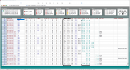
DJIFlightRecord_2021-02-14_[11-45-10].txt . The corresponding .DAT file is not provided so the depth of analysis is limited .
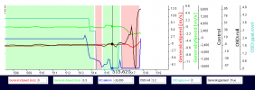
The marked time point in the chart below is 1 second before the collision. Full left aileron was applied but the craft kept banked slightly to the right by about 3 degrees. The video shows that the craft moved to the right as well so the banking angle is consistent with the actual movement of the craft.
View attachment 125098
On the surface this seems unreasonable but let's look at it from the flight controller's perspective - It saw a y-speed of +0.5 m/s. What does it mean ? From what I have seen, the definition of y-speed depends on whether GPS is used :
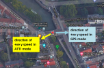
GPS mode : y-speed is the East component of the horizontal speed. +ve y-speed means the craft has a speed component towards the
east
ATTI mode : y-speed is the speed component towards the
right of the craft.
Applying these definitions to this case, there are two opposite interpretations :
View attachment 125099
As shown in the chart, GPS was used at that moment although the signal quality was zero. The craft was still logically in GPS mode. The fused sensor output told the flight controller that the craft was moving to it's left ( light blue direction in the map above ) which is the same as the direction of aileron stick input so things looked OK to the flight controller.
Obviously, the fused sensor output was wrong because the craft was actually moving to the right. I can only attribute the error to poor GPS signals.
So I guess the take-away from this case is don't fly under marginal GPS signals + poor vision positioning conditions which can cause unexpected behaviors of this kind.


