Hi y'all,
We just released update v2.5 of our OpenAthena app for iPhones and iPads. This update simplifies and expedites drone use for critical tasks such as Search and Rescue, precision agriculture, law enforcement, and land management.
Unlike other methods that require many photos and lots of time, OpenAthena calculates location instantly from a single image, letting you focus more on your mission.
Simply load your image from any compatible drone and tap anywhere within the image. The software then instantly calculates your selected point's exact ground location using OpenAthena's custom terrain-raycast geodesy engine.
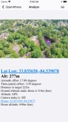
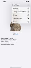
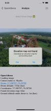
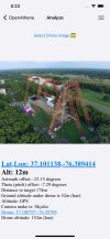
What's new in 2.5:
* Simplified the user interface so image loading and target selection occur on the same screen
* Added switch for imperial vs metric units for distance values
* Shortened the Unique ID label for ATAK Cursor on Target messages
* Fixes for UI dark mode
* Activity indicator which shows while an elevation map is downloading for your drone image
OpenAthena on the App Store:
OpenAthena
We're excited to hear about what you can do with it!
If you have any questions or feedback, please post here or contact us at:
[email protected]
Some DJI drones do not store enough metadata in their images for our software to operate on them. These are known incompatible drone models:
We just released update v2.5 of our OpenAthena app for iPhones and iPads. This update simplifies and expedites drone use for critical tasks such as Search and Rescue, precision agriculture, law enforcement, and land management.
Unlike other methods that require many photos and lots of time, OpenAthena calculates location instantly from a single image, letting you focus more on your mission.
Simply load your image from any compatible drone and tap anywhere within the image. The software then instantly calculates your selected point's exact ground location using OpenAthena's custom terrain-raycast geodesy engine.


What's new in 2.5:
* Simplified the user interface so image loading and target selection occur on the same screen
* Added switch for imperial vs metric units for distance values
* Shortened the Unique ID label for ATAK Cursor on Target messages
* Fixes for UI dark mode
* Activity indicator which shows while an elevation map is downloading for your drone image
OpenAthena on the App Store:
OpenAthena
We're excited to hear about what you can do with it!
If you have any questions or feedback, please post here or contact us at:
[email protected]
Some DJI drones do not store enough metadata in their images for our software to operate on them. These are known incompatible drone models:
- DJI Phantom 4 (not inc. Pro or Advanced versions, model FC330 only)
- DJI Mini 2
- DJI Mini 3 (not inc. Pro version)
- DJI Air 2 S (old firmware)


